SECO Energy Prepared for Hurricane Michael’s Outer Bands
SECO Energy has been closely monitoring Hurricane Michael and its outer storm bands that bring the possibility of heavy rainfall, winds and even tornado threats into Central Florida.
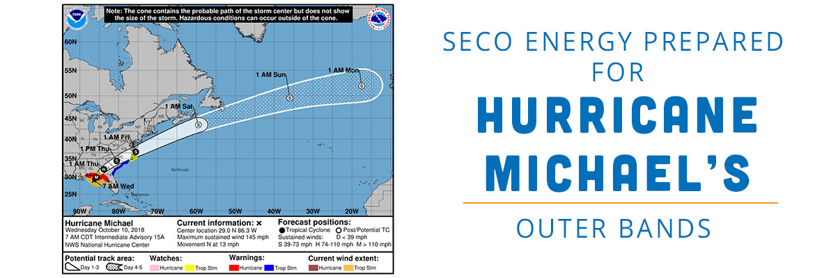
According to the National Hurricane Center (NHC), as of 7 a.m. CDT on Wednesday, Hurricane Michael is moving north at 12 mph and is located 90 miles southwest of Panama City in the Florida Panhandle. Michael has quickly picked up speed and intensity to become a Category 4 hurricane. Forecasters project landfall will be early this afternoon between Panama City and Pensacola.
Tropical storm force winds extend 150 miles from the hurricane’s center. The hurricane’s current position puts SECO’s service territory outside of this range. SECO’s area is forecast to have winds in the 20 mph range, but wind gusts and rain in the outer bands will impact Marion and Levy Counties.
Though wind speeds will not be hurricane or tropical storm force in SECO’s territory, strong storm bands passing through SECO’s service territory are a significant threat. Members should prepare for a rainy Wednesday and possibly Thursday. Heavy rains coupled with wind, could cause trees to fall and result in power outages. Tornadoes spawned by these winds and rains are a danger as well.
After the threat of storm bands from Hurricane Michael have passed the area, SECO plans to release contracted Pike crews to the North Florida areas damaged by the hurricane to aid in restoration. Additionally, a module of SECO employees will be sent for restoration aid after hurricane dangers have passed.
CEO Jim Duncan asks members to remain vigilant, “Hurricane Michael will not make landfall near SECO’s service territory, but members will experience rains and high wind gusts. Be alert for the possibility of tornadoes which can be extremely dangerous. My thoughts and prayers go out to the Panhandle residents in the direct path. I’m grateful that SECO is in the position to send reinforcements to damaged areas.”
SECO Energy is StormReady and is committed to keeping members informed of weather that impacts the area. Visit Storm Preparation online to view an emergency checklist and storm preparation ideas. Watch our Facebook and Twitter pages for Tropical Storm Michael updates. Most important, be sure you’ve bookmarked our new StormCenter outage map and set your email, text and voice notifications preferences. StormCenter is mobile friendly and designed to perform on smartphones and tablets.