SECO Energy Preparing for Wind and Rain from Hurricane Michael
SECO Energy is preparing for the possibility of high winds, rain and the threat of tornadoes in Central Florida from Hurricane Michael’s outer bands.
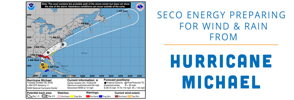
As of 7 a.m. CDT on Tuesday, Hurricane Michael has picked up speed and is moving north-northwestward through the southern Gulf of Mexico at 12 mph. Hurricane Michael is currently a Category 2 hurricane with winds speeds between 96 and 110 mph. Tropical storm force winds extend 150 miles from the hurricane’s center.
According to the National Hurricane Center (NHC), Michael is strengthening and forecasters believe the storm will continue to increase in speed and intensity before making landfall near Panama City in the Florida Panhandle Wednesday afternoon.
SECO forecasters project the strongest winds to remain outside of our service area. Marion and Levy County members will experience the brunt of the strong winds, but still well below 30 mph. The tropical storm force wind speeds should remain at least 50 miles outside of SECO’s territory.
Though wind speeds will not be hurricane force, be only slightly high, strong storm bands passing through SECO’s service territory are a significant threat. Members should prepare for large amounts of rain beginning Tuesday and lasting through Thursday, coupled with wind, could cause trees to fall and result in power outages. Additionally, the threat of tornadoes will increase on Wednesday and into Thursday. Strong storms have impacted the east coast early this morning.
Citrus County’s Emergency Operating Center (EOC) is activating as of 5 p.m. today, and they have issued an evacuation order for coastal areas and manufactured homes as of 3 p.m. today. Citrus County is opening four shelters today, and schools are closed through Wednesday. The Sumter, Lake, Marion, Levy, Hernando and Pasco EOCs are monitoring the storm closely. A coastal evacuation order is in effect in Levy and two shelters open there today.
CEO Jim Duncan assures members that SECO is prepared for inclement weather created by Hurricane Michael. Duncan stated, “SECO continues to closely monitor Hurricane Michael’s progress as it travels through the Gulf of Mexico. We are prepared for Hurricane Michael’s rain bands and winds that will reach into our service territory. SECO’s employees, contract crews and leadership team are all prepared to escalate our response if Hurricane Michael’s path shifts toward SECO’s area.”
Duncan added, “Members should continue to keep a close eye on Hurricane Michael. Forecasted tracks have been known to shift hourly right up until landfall. Gather your hurricane supplies now if you have not already done so.”
SECO Energy is StormReady and is committed to keeping members informed of weather that impacts the area. Visit our Storm Preparation page online to view an emergency checklist and storm preparation ideas. Watch our Facebook and Twitter pages for Tropical Storm Michael updates. Most important, be sure you’ve bookmarked our new StormCenter outage map and set your email, text and voice notifications preferences. StormCenter is mobile friendly and designed to perform on smartphones and tablets.