July 2024 Sunshine State Stats
In July 2024, the average high and low temperatures climbed higher from last month, along with increased lightning and thunderstorms across Central Florida. The month’s average high was 94 degrees, and the low was 76, both temperatures were 1 degree higher than June. The average high for July increased by 2 degrees and the average low was 1 degree higher than the “normal” average temperatures as recorded at Leesburg International Airport (KLEE). The month’s highest temperature was recorded on July 8, touching 97 degrees; the lowest temperature was 72 degrees and occurred on July 19.
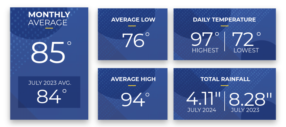
Reported rainfall in July totaled 4.11 inches, 1.66 inches lower than in June and 1.56 inches lower than the “normal” amount for July. Measurable rainfall for July began on the 4th and occurred on 16 of 31 days. The rainiest day was July 19, when 1.02 inches fell.
WeatherSentry detected 28,330 cloud-to-ground lightning strikes within a 20-mile radius of Leesburg International Airport in July. The most active period was the last 15 days of the month when lightning struck 19,659 times versus 8,671 times during the first 16 days.
Lightning Archive Report – 20-mile radius from Leesburg International Airport (KLEE)
Data and charts provided by weathersentry.dtn.com
 Cloud to Ground Lightning – July 1-16, 2024 (8,671 strikes)
 Cloud to Ground Lightning – July 17-31, 2024 (19,659 strikes)
Thunderstorms are a frequent occurrence in the summer in Central Florida. SECO Energy reminds members to seek shelter promptly if a thunderstorm approaches.
August Forecast from The Old Farmer’s Almanac:
The Old Farmer’s Almanac weather forecast for August 2024 predicts warm and mild temperatures with thunderstorms in the north and sunshine in the south the first 6 days, followed by 5 days of isolated thunderstorms, and 8 days of sunny weather in the north and thunderstorms in the south. The forecast projects additional thunderstorms in the south and a hurricane threat for the north between August 25-28, followed by 3 days of sunny and warm conditions.
The estimated average temperature for August is 85 degrees, and the expected rainfall is 7 inches, 1 inch below average.
Stay Informed
StormCenter is SECO Energy’s outage and communications platform for members to report outages, check the status of an existing outage, and enroll in outage communications and alerts via email, text, voice, or all three. Visit StormCenter today and bookmark it on your smartphone or tablet to report outages quickly and easily.
Protect Your Appliances
Power surges are sudden, powerful increases in voltage that can damage or destroy household appliances and electronics. SECO Energy’s Surge Mitigator™ program offers a meter-based surge arrester designed to protect large appliances, such as motors and compressors, by reducing surges at the meter before they enter your home. Members can lease or purchase the Surge MitiGator surge protection program by completing a contact form.
Hurricane Preparedness
Hurricane Season is now in its third month. It’s crucial to prepare in advance for any storm. Refer to the SECO Energy Hurricane Handbook available online here, or pick up a printed copy at one of our Member Service Centers.
Online Energy-Efficiency Tools
Log into SmartHub to view past bills and consumption charts to check historical usage. If you want help reducing your energy usage, SECO offers several energy-efficiency tools to help you identify energy wasters. Take the Home Energy Assessment to receive a detailed email tailored to your home’s features and lifestyle. The energy-saving advice will provide low-cost ways to decrease your usage – and your electric bill.
To easily calculate how much energy your appliances, lighting, electronic devices, and other energy-using items in your home consume, use the Energy Estimator.