August 2024 Sunshine State Stats
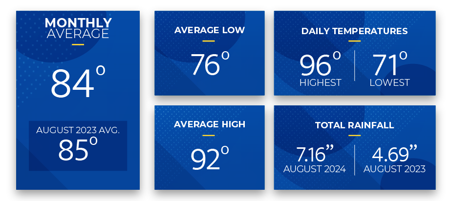
In August 2024, Central Florida experienced an increase in rainfall and slightly cooler temperatures compared to the previous month. The average high for August was 92 degrees, 2 degrees cooler than July, while the average low remained steady at 76 degrees. The average high and low for August matched historical “normal” average temperatures recorded at Leesburg International Airport (KLEE). The highest temperature of the month was recorded on August 27, reaching 96 degrees; the lowest temperature was 71 degrees and recorded on August 17.
Reported rainfall in August totaled 7.16 inches, 3.05 inches more than in July and 2.47 inches more than August of last year. Measurable rainfall for August began on the 1st and occurred on 18 of 31 days. The rainiest day was during Hurricane Debby on August 5th, when 4.25 inches fell.
Thunderstorms are common in the summer in Central Florida. SECO Energy encourages members to seek shelter promptly if a thunderstorm approaches.
September Forecast from The Old Farmer’s Almanac:
The Old Farmer’s Almanac weather forecast for September 2024 predicts warm temperatures and thunderstorms for the first 13 days. For the latter half of the month, the forecast suggests slightly cooler temperatures with continued thunderstorms in the South and sunshine in the northern regions from September 24-30.
The estimated average temperature for September is 80 degrees, and the expected rainfall is 9.5 inches, 2 inches above average.
Stay Informed
StormCenter is SECO Energy’s outage and communications platform for members to report outages, check the status of an existing outage, and enroll in outage communications and alerts via email, text, voice, or all three. Visit StormCenter today and bookmark it on your smartphone or tablet to report outages quickly and easily.
Protect Your Appliances
Power surges are sudden, powerful increases in voltage that can damage or destroy household appliances and electronics. SECO Energy’s Surge Mitigator™ program offers a meter-based surge arrester designed to protect large appliances, such as motors and compressors, by reducing surges at the meter before they enter your home. Members can lease or purchase the Surge MitiGator surge protection program by completing a contact form.
Hurricane Preparedness
September is the peak of Hurricane Season! It’s crucial to prepare in advance for any storm. Refer to the SECO Energy Hurricane Handbook available online here, or pick up a printed copy at one of our Member Service Centers.
Online Energy-Efficiency Tools
Log into SmartHub to view past bills and consumption charts to check historical usage. If you want help reducing your energy usage, SECO offers several energy-efficiency tools to help you identify energy wasters. Take the Home Energy Assessment to receive a detailed email tailored to your home’s features and lifestyle. The energy-saving advice will provide low-cost ways to decrease your usage – and your electric bill.
To easily calculate how much energy your appliances, lighting, electronic devices, and other energy-using items in your home consume, use the Energy Estimator.


