SECO Energy Tracking Hurricane Idalia
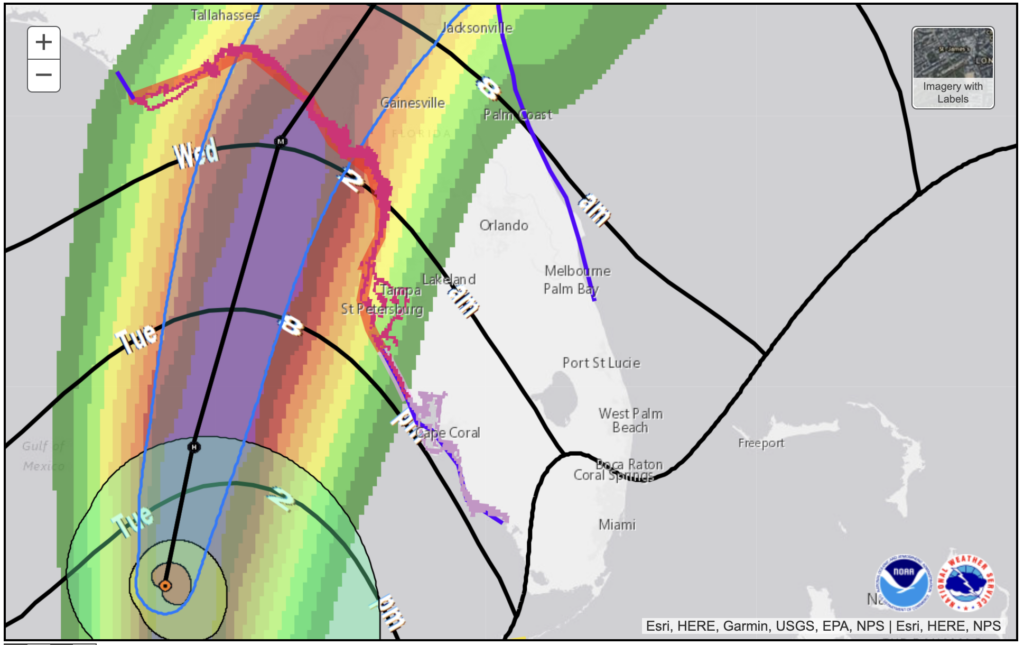
SECO Energy continues to track the path of Hurricane Idalia as it moves through the Gulf of Mexico toward the Florida Peninsula. As expected, Idalia strengthened into a hurricane overnight and accelerated its movement north. At 11:00 a.m., the hurricane was positioned 240 miles southwest of Tampa, and its sustained winds were measured at 90 mph. Hurricane Idalia is moving due north at 15 mph and is expected to make landfall near Cedar Key early Wednesday morning.
 The onset of Hurricane Idalia’s winds is projected to be felt in the western SECO Energy service territories of Citrus, Levy, Marion and Sumter Counties this evening. Hurricane-force winds extend outward up to 15 miles from the center, and tropical storm-force winds extend up to 160 miles. These winds are expected to intensify rapidly overnight and result in a major hurricane by the time it makes landfall on Florida’s Gulf Coast Wednesday morning.
Based on the National Hurricane Center (NHC) forecast, the risk of life-threatening storm surges and tropical storm-force winds along portions of Florida’s west coast is still a concern. The highest surge levels are predicted to fall within 10-15 feet above sea level. SECO Energy members should monitor updates to the forecast and follow advice given by local officials.
SECO Energy members should prepare for outages due to Hurricane Idalia beginning overnight on Tuesday and into early Wednesday morning. If the current track stays in place, Marion County could experience winds between 60 – 70 mph and Citrus, Sumter and Lake Counties could have wind speeds between 40 – 60 mph. High wind speeds and possible flooding and tornadoes may create power outages that last for an extended period of time.
CEO Curtis Wynn repeated his call for vigilance from members in advance of Idalia’s impact. Wynn stated, “SECO Energy is preparing for the effects of Hurricane Idalia. This coordinated, company-wide effort integrates assistance from other energy cooperatives and contractor partners ahead of the storm. Along with SECO Energy’s 80 line crew employees, we expect over 250 contracted line crews and 150 contracted tree service crews. After Hurricane Idalia has cleared our area, if needed, we will bring in additional support from our fellow electric cooperatives that were unaffected by the storm. The unfortunate consequences of power outages from tropical storms and hurricanes are a fact of life, but the duration of these outages is mitigated by the advanced preparations made by our leadership team, dedicated staff, and line technicians.”
Wynn cautioned against complacency, adding, “I want to remind members not to take this storm lightly. High winds and heavy rain will increase the risk of downed power lines and trees. What was an ordinary activity a few days ago could be unsafe after a storm. Take time today to make any last-minute preparations, but if you don’t need to travel, stay home.”
SECO’s priority is to restore service for shelters, hospitals, schools and government agencies (i.e., emergency ops centers, fire stations, law enforcement facilities). SECO Energy members who require electricity for life-sustaining medical equipment should consider relocating to a shelter.
StormCenter is SECO Energy’s outage and communications platform for members to report outages, check the status of an existing outage and enroll in outage communications and alerts via email, text, voice or all three. Visit StormCenter today and bookmark on your smartphone or tablet to report outages quickly and easily.
“Like” SECO Energy on Facebook and follow @SECOEnergy on X (formerly Twitter) for prize drawings, news releases, and severe weather alerts affecting SECO Energy’s service territory. Manage your outage notification preferences at StormCenter. To see when SECO Energy crews/contractors are working in your area, visit our new System Improvement map. To learn more about SECO Energy as a not-for-profit cooperative, visit SECOEnergy.com>Your Co-op>About.


