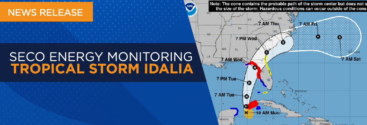
SECO Energy Monitoring Tropical Storm Idalia
SECO Energy is preparing for the weather effects of Tropical Storm Idalia as it targets the Florida Peninsula. The storm is expected to strengthen into a major hurricane before it reaches the Gulf Coast of Florida.
Based on the National Hurricane Center (NHC) forecast, the risk continues to increase for life threatening storm surge and dangerous hurricane force winds along portions of Florida’s west coast and the Florida Panhandle beginning as early as late Tuesday. Storm surge and hurricane watches are in effect for much of Florida’s west coast. SECO Energy members should monitor updates to the forecast and follow advice given by local officials. Florida Governor Ron DeSantis has declared a State of Emergency to 46 counties, up from 33 on Saturday.
Tracking Tropical Storm Idalia
The current track of the storm shows that TS Idalia will most likely impact SECO Energy’s service area on Tuesday with rain and increased wind speeds. Outages on SECO’s electric system are possible overnight on Wednesday and into the early morning hours. If the current track stays in place, Marion County could experience winds between 60 – 70 mph and Citrus, Sumter and Lake Counties could have wind speeds between 40 – 60 mph.
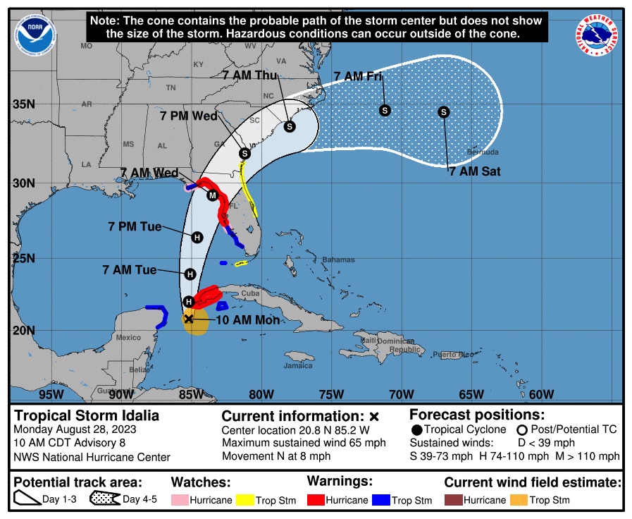
As of Monday morning, this storm was moving north over far western Cuba where later today it is expected to impose hurricane-force winds, heavy rainfall, the possibility of flash and urban flooding as well as landslides.
CEO Curtis Wynn urges members to prepare for Tropical Storm Idalia. Wynn stated, “SECO Energy is watching Tropical Storm Idalia closely and preparing for the impacts this storm will have on our service area. While SECO is StormReady and prepared to respond to power outages, I urge members to prepare for major hurricane-force conditions. We expect this storm will impact SECO’s service area by late Tuesday, so now is the time to make safety preparations for your homes and families before its arrival. Still—be safe in efforts to prepare. Exercise caution and patience on the roads and continue to watch weather reports and follow the storm’s track.”
StormCenter is SECO Energy’s outage and communications platform for members to report outages, check the status of an existing outage and enroll in outage communications and alerts via email, text, voice or all three. Visit StormCenter today and bookmark on your smartphone or tablet to report outages quickly and easily.
Major weather events can cause extended power outages. SECO Energy reminds members to follow safety protocols when using a generator during a power outage. Generators emit deadly carbon monoxide (CO) that is odorless and colorless. Thousands of people die each year from CO poisoning. Never operate a generator in an enclosed space, including a garage. Always place the generator at least 15 to 20 feet away from your home and never near open windows.
Before operating a generator, thoroughly read and review the owner’s manual. Never plug a generator directly into an electrical outlet. This current flow is deadly for utility personnel. Keep children away from an operating generator and store fuel in approved containers. Do not smoke while fueling a generator. Always operate a generator in a dry space. If it is raining, use a canopy or cover. SECO Energy’s Hurricane Handbook includes generator safety tips and how to prepare for before, during and after a storm.
“Like” SECO Energy on Facebook and follow @SECOEnergy on Twitter for prize drawings, news releases, and severe weather alerts affecting SECO Energy’s service territory. Manage your outage notification preferences at StormCenter. To see when SECO Energy crews/contractors are working in your area, visit our new System Improvement map. To learn more about SECO Energy as a not-for-profit cooperative, visit SECOEnergy.com>Your Co-op>About.