SECO Monitoring Ever-changing Tropical Forecast
SECO Energy continues to monitor this week’s ever-changing tropical forecast on Monday. With the peak of Atlantic Hurricane season fast-approaching, SECO encourages members to pay close attention to tropical weather alerts.
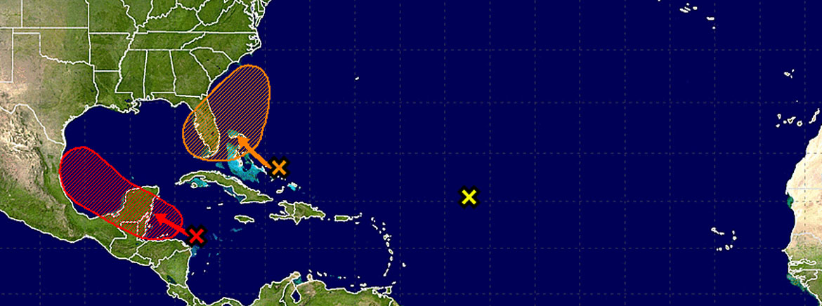
The National Hurricane Center (NHC) continues to track Invest 92L also known as Disturbance 2. Invest 92L is located a couple of hundred miles north-northeast of the southern Bahamas and continues to produce disorganized showers and thunderstorms extending toward Puerto Rico. Invest 92L is expected to continue moving west-northwestward at 15 to 20 miles per hour during the next few days.
Invest 92L’s current prediction cone encompasses all of Florida except for the panhandle. It is unlikely that Invest 92L will develop into a tropical storm or hurricane, but forecasters predict the system will bring rain and occasional gusty winds to SECO’s service area Thursday morning. Parts of SECO’s service area have been inundated with heavy amounts of rain and the ground is already wet. This saturation can lead to flooding and falling trees.
Forecasters are also watching Tropical Storm Harvey, which is breaking up near the Yucatan Peninsula and Disturbance 3, which has zero percent chance of cycle formation over the next five days.
SECO employees are Storm Ready and waiting to respond if outages occur. SECO is prepared for inclement weather and reminds members that it is best to be informed and prepared.
If you have a portable or backup generator, now is the time to test that it is running properly and you have an adequate supply of fuel on hand. Members can visit SECO’s storm preparation page for storm preparation tips and an emergency checklist. For members with smartphones or tablets, bookmark SECO’s Storm Center for easy outage reporting and updates.
As a not-for-profit electric cooperative, SECO is dedicated to being our members’ first source for accurate storm information. “Like” SECO’s Facebook page and “follow” the company on Twitter to stay updated about storms affecting our area.


