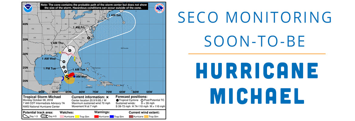
SECO Monitoring Soon-to-be Hurricane Michael
SECO Energy is monitoring the soon-to-be Hurricane Michael as it moves north toward Florida’s gulf coast.
The current Tropical Storm Michael is on the verge of being upgraded to Hurricane Michael. As of 4 a.m. CDT on Monday, Hurricane Michael is slowly moving north at 7 mph with sustained winds of 70 mph.
The National Hurricane Center (NHC) forecasts Michael to increase in both speed and intensity over the next 48 hours. The storm is predicted to make landfall in the Apalachicola area late Wednesday night into early Thursday morning. As Michael moves into the Gulf of Mexico, it may strengthen significantly – forecasters predict Michael’s strength at landfall may be as high as a Category 2 or 3.
SECO members should prepare for the likelihood of gusty winds for most of SECO’s seven county service area. SECO members in the western portions of the service area, including large numbers in Citrus, Marion and Sumter Counties, will likely experience the strongest sustained winds.
CEO Jim Duncan is urging SECO members to prepare for Michael. Duncan stated, “Tropical Storm Michael, soon to become Hurricane Michael, is on track to make landfall on Florida’s west coast. Ensure that your hurricane supplies are fully stocked and that you and your family are prepared for the possibility that Michael’s high wind speeds will cause power outages. At SECO, we are carefully watching this storm, and I encourage our members to do the same.”
SECO Energy is StormReady and is committed to keeping members informed of weather that impacts the area. Learn more about Storm Preparation online and view an emergency checklist. Watch our Facebook and Twitter pages for Tropical Storm Michael updates. Most important, be sure you’ve bookmarked our new StormCenter outage map and set your email, text and voice notifications preferences. StormCenter is mobile friendly and designed to perform on smartphones and tablets.