StormCenter logo

Archive

August 2024 Sunshine State Stats

In August 2024, Central Florida experienced an increase in rainfall and slightly cooler temperatures compared to the previous month. The average high for August was 92degrees, 2 degrees cooler than July, while the average low remained steady at 76 degrees. The average high and low for August matched historical “normal” average temperatures recorded at Leesburg International Airport (KLEE). The highest temperature of the month was recorded on August 27, reaching 96 degrees; the lowest temperature was 71 degrees and recorded on August 17. 


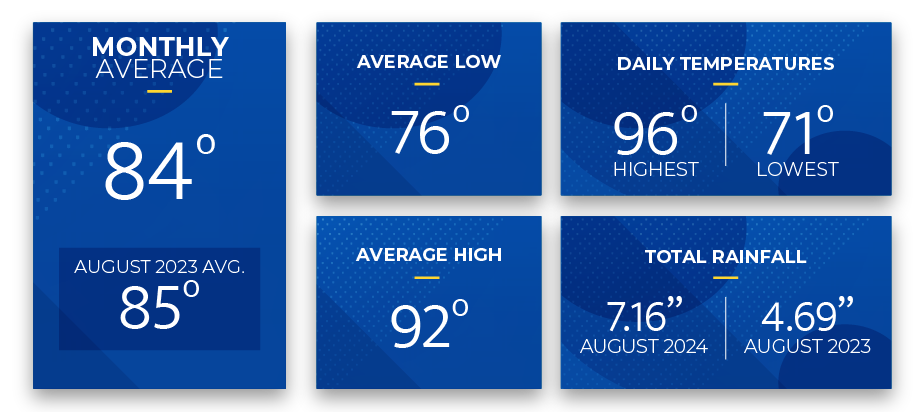
Reported rainfall in August totaled 7.16 inches, 3.05 inches more than in July and 2.47 inches more than August of last year. Measurable rainfall for August began on the 1st and occurred on 18 of 31 days. The rainiest day was during Hurricane Debby on August 5th, when 4.25 inches fell. 


WeatherSentry detected 7,074 cloud-to-ground lightning strikes within a 20-mile radius of Leesburg International Airport in August. The most active period was the first 15 days of the month when lightning struck 5,253 times versus 1,821 times during the last 16 days.


Lightning Archive Report – 20-mile radius from Leesburg International Airport (KLEE) 

Data and charts provided by weathersentry.dtn.com 

Cloud to Ground Lightning  –  August 1 – 15, 2024  (5,253  strikes)  


Cloud to Ground Lightning –  August 16 – 31, 2024  (1,821 strikes)  


Thunderstorms are common in the summer in Central Florida. SECO Energy encourages members to seek shelter promptly if a thunderstorm approaches.


September Forecast from The Old Farmer’s Almanac:

The Old Farmer’s Almanac weather forecast for September 2024 predicts warm temperatures and thunderstorms for the first 13 days. For the latter half of the month, the forecast suggests slightly cooler temperatures with continued thunderstorms in the South and sunshine in the northern regions from September 24-30. 


The estimated average temperature for September is 80 degrees, and the expected rainfall is 9.5 inches, 2 inches above average. 


Stay Informed 

StormCenter is SECO Energy’s outage and communications platform for members to report outages, check the status of an existing outage, and enroll in outage communications and alerts via email, text, voice, or all three. Visit StormCenter today and bookmark it on your smartphone or tablet to report outages quickly and easily. 


Protect Your Appliances 

Power surges are sudden, powerful increases in voltage that can damage or destroy household appliances and electronics. SECO Energy’s Surge Mitigator™ program offers a meter-based surge arrester designed to protect large appliances, such as motors and compressors, by reducing surges at the meter before they enter your home. Members can lease or purchase the Surge MitiGator surge protection program by completing a contact form. 


Hurricane Preparedness 

September is the peak of Hurricane Season! It’s crucial to prepare in advance for any storm. Refer to the SECO Energy Hurricane Handbook available online here, or pick up a printed copy at one of our Member Service Centers.  


Online Energy-Efficiency Tools 

Log into SmartHub to view past bills and consumption charts to check historical usage. If you want help reducing your energy usage, SECO offers several energy-efficiency tools to help you identify energy wasters. Take the Home Energy Assessment to receive a detailed email tailored to your home’s features and lifestyle. The energy-saving advice will provide low-cost ways to decrease your usage – and your electric bill.  


To easily calculate how much energy your appliances, lighting, electronic devices, and other energy-using items in your home consume, use the Energy Estimator.

August 2023 Sunshine State Stats

In August 2023, the average high and low temperatures rose slightly from July’s figures. The average high temperature rose 2 degrees, to 94, and the average low inched 1 degree higher than July, settling at 76 degrees. Rainfall reported from Leesburg International Airport (KLEE) decreased significantly from the month prior.  


Central Florida escaped much of Hurricane Idalia’s impact, which devastated coastal areas north of SECO Energy’s service territory. While measurable precipitation occurred on only 10 of 31 days, late afternoon thunderstorm activity maintained its presence throughout the month. August 2023 rainfall totaled 4.69 inches, 3.59 inches less than the total rainfall in July. 


August 2023 Sunshine State Stats temps


The average temperature for August 2023 was 85 degrees (1 degree higher than last month’s average), yet the daily high temps hit 90 degrees or above on all but one day. The highest daily recorded temperature (data from the Leesburg KLEE weather station) in August was 98 degrees and the lowest was 73 – matching the highest daily recorded temperature in July, and exceeding July’s lowest by 1 degree.   


For most of August, the entire state of Florida was under heat advisories or excessive-heat warnings. As the heat index in many parts of Central Florida topped 110 degrees, on Sunday, August 13, SECO Energy recorded an instantaneous system peak of 984.3 megawatts at 5:00 p.m. This peak load shattered the previous record of 949 set in July 2023. 


HVAC is the largest energy user in Central Florida homes, accounting for an average of 35 to 40% of kWh usage. This next month may be a good time to consider revisiting your thermostat settings to take advantage of savings opportunities presented by moderating temperatures. The energy-efficient thermostat setting during hotter months is 78 degrees and during colder months it is 68 degrees.


What are Cooling/Heating Degree Days? 

Cooling Degree Day (CDD) scores represent the difference between the mean temperature for a given day (the high temp + the low temp, divided by 2) and 65 degrees. A positive number represents a Cooling Degree Day and the higher the number, the further the mean temperature was from 65 degrees. In colder months, there are days where the difference between the mean temperature and 65 degrees is a negative number. This represents a Heating Degree Day (HDD). In August, the monthly CDD score was 628. By contrast, the April 2023 CDD was 292, while there were no HDDs recorded.


September forecast from The Old Farmer’s Almanac:  

The weather outlook for September 2023 indicates a monthly average temperature in the lower 80s with precipitation totals about 2 inches lower than average. Look for scattered showers and a few thunderstorms throughout the month with some noticeable periods of partly cloudy days mixed in. 


The Atlantic hurricane season enters its final two months, and the updated storm predictions from Colorado State University suggest we may still experience an “above-normal season.” Read the details in the September SECO News. 


Online Energy-Efficiency Tools  

Log into SmartHub to view past bills and consumption charts to check historical usage. If your usage is high, SECO offers several energy-efficiency tools to help you identify energy wasters. Take the Home Energy Assessment to receive a detailed email tailored to your home’s features and lifestyle. The energy-saving advice will provide low-cost ways to decrease your usage – and your electric bill. 


To easily calculate how much energy your appliances, lighting, electronic devices, and other energy-using items in your home consume, use the Energy Estimator. 

August 2021 Sunshine State Stats

Hot summer temperatures continued in August 2021 as the highest daily temperature recorded was 99 degrees. The lowest recorded temperature for the month was 73 degrees. Rainfall decreased from last month to measure 4.8 and is below August’s average of 7.76 inches.


August 2021 Sunshine State Stats temps


During August’s 31 days, 24 of those reached a high temp of over 90 degrees. Because of the increased temperatures, members will likely notice an increase in their August electric usage.


For August 2021 the average temperature was 85 degrees, which is one degree higher than the average temperature in August 2020. The average high temperature in August 2021 was 93 degrees, and the average low temperature was 77.


Both the average monthly temperature and average low and high temperatures have increased from July 2021. Again, members will likely see an increase in their energy usage for August 2021. Hotter temperatures and increased humidity mean HVACs will run for longer periods of time and more frequently to keep the temperatures cool inside. Daily temperature fluctuations also increase HVAC usage.


September forecast:


September is the peak of hurricane season. The Old Farmer’s Almanac predicts a tropical storm threat September 8 – 12. Daily highs will reach into the 90s with lows in the 70s with the chance of scattered thunderstorms that bring rain, lightning and wind during the middle of the month.


Take the bite out of damaging surges and spikes with SECO Energy’s Surge MitiGator surge protection. Our meter-based surge arrester protects large appliances by reducing surges BEFORE they enter the meter. Learn more about the Surge MitiGator. In September, members enrolled in surge protection are entered in a drawing to win a portable generator each month. Enroll today for the chance to win!


To check historical usage, log into SmartHub to view past bills and consumption charts. If your usage is high, SECO offers several energy-efficiency tools to help you identify energy wasters. Take the Home Energy Assessment to receive a detailed email tailored to your home’s features and lifestyle. The energy-saving advice will provide low-cost ways to decrease your usage – and your electric bill.


To easily calculate how much energy your appliances, lighting, electronic devices, and other energy-using items in your home consume, use the Energy Estimator.