StormCenter logo

Archive

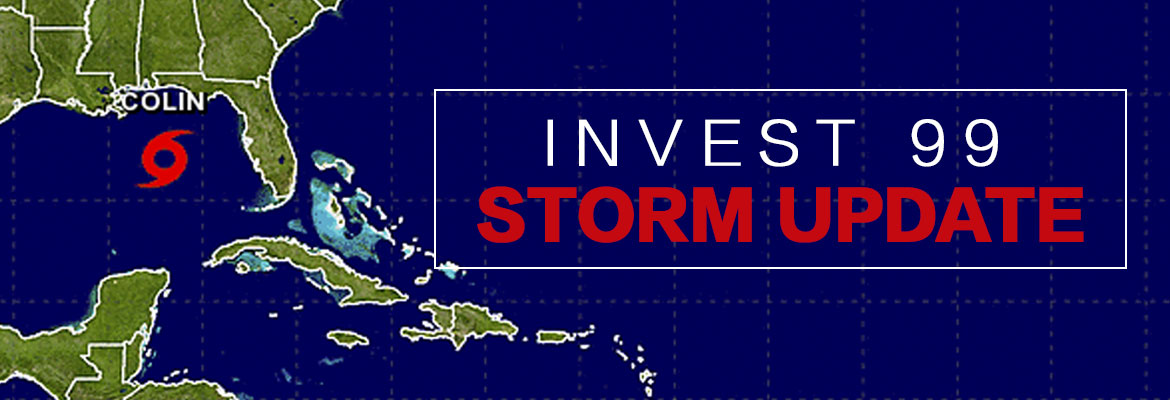
Tropical Depression #9 Tracking to Florida

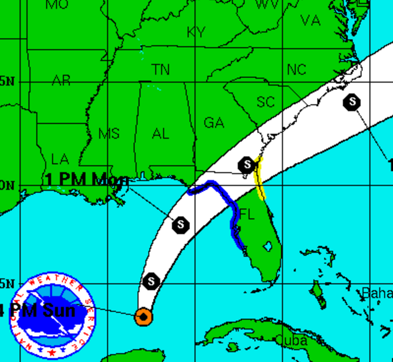
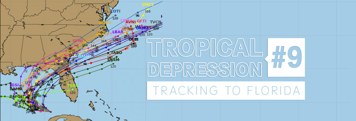
National Hurricane Center has upgraded Invest 99 to Tropical Depression #9 (TD#9). As of Monday morning, the storm is currently located 25 to 35 miles northwest of Havana, Cuba and 100 miles southwest of Key West, Florida. Tropical Depression #9 is expected to track west to west-northwest and into the southeastern Gulf of Mexico through Monday.


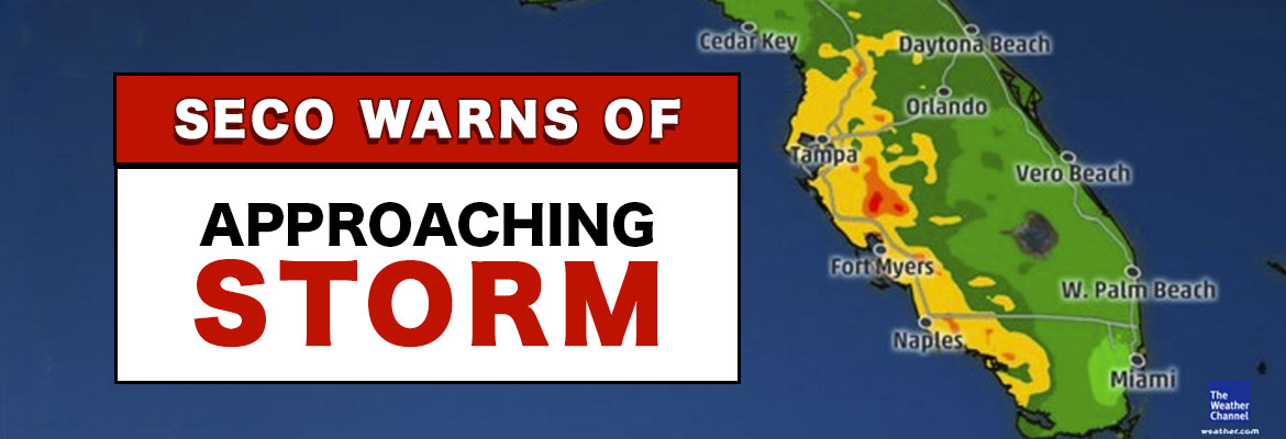
This system is expected to strengthen and organize into a tropical storm as it moves into the warmer waters of the Gulf on Tuesday and Wednesday. On Thursday, this system is forecasted to turn northeastward and then eastward – landfall is projected in the Florida Panhandle by most models.


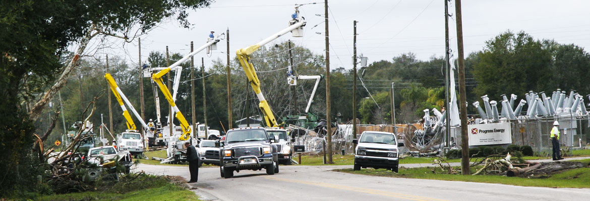
The forecast above is based on the NHC projections for the state. SECO’s service area specifically, will likely experience heavy rainfall, sustained winds upward of 40 mph and periods of stronger gusts, especially on Thursday and Friday. Members can expect tree-caused outages due to the wind and rain.


SECO is Storm Ready. Our locally-based customer service staff is ready and available to respond to member inquiries in person, by phone or online. SECO’s Operations leadership directs the SECO cavalry 24 hours a day, seven days a week – each truck is equipped to respond to member concerns or service interruptions in the field quickly and safely. Additional Operations personnel are staged to respond quickly this week. Members should ensure their smartphones/tablets are charged and report outages online through Storm Center.


SECO has provided an emergency checklist for members on the Storm Preparation section of our website.


As a not-for-profit electric cooperative, SECO is dedicated to being its members’ first source for accurate storm information. “Like” SECO’s Facebook page and “follow” the company on Twitter to stay updated about storms affecting your area. For members who rely on back-up generators during storm season, remember to read and follow all manufacturer’s safety warnings. Learn more about generator safety here.

SECO Monitoring Atlantic Storms

According to the National Oceanic and Atmospheric Administration (NOAA), the most active period in the Atlantic Hurricane season begins in mid-August and ends in mid-October. SECO Energy continues to monitor tropical depression Invest 99 and the possibility it could make landfall in Florida early next week.


As of late Thursday afternoon, tropical wave Invest 99 is an unorganized, broad area of low pressure moving westward at 15 to 20 mph through the southeastern Bahamas. Winds associated with the system have decreased to below tropical storm strength.


Spaghetti models are predicting possible landfall in southern Florida or continue into the southeastern Gulf of Mexico. If conditions are favorable, the depression could strengthen and become Hurricane Hermine as early as Friday. At that point, the storm could pick up steam and make landfall again somewhere on Florida’s west coast. This system could bring heavy rain and winds to SECO’s service area early next week.


Even though it is too early to predict when and how Central Florida will be affected, SECO is urging members to make preparations in advance. SECO has provided an emergency checklist for members on our website.


Kathryn Gloria, Vice President of Corporate Communications and Energy Services stated, “It has been 11 years since Hurricane Wilma made landfall in Florida, and members may feel confident that Florida will continue to be lucky and larger storms will pass us by. Emergency supplies sell out quickly when storm watches and warnings go into effect, gather your supplies beforehand. I urge all SECO members to prepare for the possibility of increased storm activity during this peak time.”


SECO Stands Storm Ready


SECO is Storm Ready. Our locally-based customer service staff is ready and available to respond to member inquiries in person, by phone or online. SECO’s System Operations directs the SECO cavalry 24 hours a day, seven days a week – each truck is equipped to respond to member concerns or service interruptions in the field quickly and safely.


As a not-for-profit electric cooperative, SECO is dedicated to being our members’ first source for accurate storm information. “Like” SECO’s Facebook page and “follow” us on Twitter to stay updated about storms affecting our area.


For members who rely on back-up generators during storm season, remember to read and follow all manufacturer’s safety warnings. Visit our website to learn more about generator safety.

Nature’s Reflections – Florida’s Gulf Fritillary

Florida’s Gulf Fritillary

A member of the longwings, brush-footed family


The Gulf fritillary (Agraulis vanillae) is a striking, bright orange, medium-sized butterfly common to Florida. Its wingspan is less than three inches. Its forewings are long and fairly narrow, orange above with black markings, and three black-encircled white or silvery spots at the front edge of the forewing. These spots are visible above and below. Underwings are pale brownish orange, with many large, iridescent silvery markings.


The Gulf fritillary gets its name from the fact that it migrates across the Gulf of Mexico. In fact, its range extends from South America north through Central America, Mexico and the West Indies to the southern United States.


SECO News Nature's Reflections August 2016, Florida’s Gulf Fritillary


The Gulf fritillary uses the passion flower vine for its larval food plant. Males patrol for females, who lay tiny yellow eggs on the host plant. The eggs usually hatch within a few days. The Gulf fritillary is considered a sub-tropical butterfly. This means it slows down when air temperatures drop and speeds up when it gets warmer regardless of what stage it is in. For example, an egg may hatch within three days in the heat of summer, but may take longer in cold weather.


Column & photo by: Sandi Staton


Nature’s Reflections – No-see-ums

No-see-ums

Can’t see them, but you can sure feel the bites


Something is biting you, but don’t see anything? If it’s summer in Florida, it’s probably No-see-ums. The tiny, most irritating insect sometimes called sand gnats or sand flies, are actually part of a family of small flies known as the biting midge (Ceratopogonidae). At less than .03 mm long, all that can be seen is a tiny speck, yet it is the smallest blood-sucking insect on the planet. Like the mosquito, only the female bites.


The bad news is, there are said to be 47 different species in Florida alone, and 4,000 worldwide. This makes it virtually impossible to know which of the species is biting since they all have similar behaviors. And frankly, once bitten, no one cares what species it is, but how to get them to stop biting.


No-see-ums are found during warm weather in all coastal areas, virtually the whole state. They are plentiful and most
annoying at the beach, in the pool, when fishing or just enjoying the outdoors. Since they are all over Florida, if you are outside under the right circumstances, they can find you. The worst biting activity occurs early in the morning and late afternoon, or during an overcast day when there is little or no wind.


Nature’s Reflections, July 2016 – No-see-ums


Adult female midges take a tiny bit of blood as a source of protein for their eggs. The number of eggs depends on the size of the adult and the amount of blood. Somewhere between 25 and 110 eggs are produced per blood meal. Eggs are laid in wet sand and hatch in three to five days as long as temperatures are at least 80° F. They are short lived, but their numbers make that a moot point.


The midge uses small cutting teeth on the elongated mandibles in its mouth to make a tiny cut in the skin – the bite. The amount of blood taken is insignificant. The irritation comes from the chemical in the saliva that is injected to prevent blood clotting and gumming up their microscopic beaks. The reaction to these chemicals causes the itchy, painful welts that can last for days. Over time, one’s immune system builds up a tolerance to these bites and the welts stop forming. The best preventative measure is avoidance during peak biting times. Repellents labeled for biting midges may offer some degree of relief.


Column & photo by: Sandi Staton


Tropical Storm Colin – Sunday evening update

The National Hurricane Center has upgraded the tropical depression to Tropical Storm Colin. The TS is now moving north at approximately 8 mph and is projected to make landfall in the Big Bend area of Florida. All models continue to focus on that area – see attached. This storm is lopsided with all the severe weather on the east side of the storm system and nothing on the west side. This means the worst rain and wind is on the side of the storm that will pass by or on top of SECO Energy.

The current track of TS Colin means that Citrus, Marion and Sumter Counties can expect the worst impact from the storm. Lake County will still see periods of rain and rain bands from TS Colin – just not as severe as the other SECO Energy counties. Since TS Colin is moving slow, it may be late on Monday before SECO sees the worst. The rain bands extend many miles to the east and north. The wind forecast for our area remains unchanged – sustained winds around 20 mph with stronger gusts in thunderstorms. SECO is STORM READY. Please be sure your phone is charged and that you bookmark our Storm Center link to report outages online.

Kathryn Gloria, Vice President of Corporate Communications and Energy Services is reminding members that SECO is Storm Ready for its members. “SECO is prepared for the almost daily afternoon storms that affect our service area and we are prepared for stronger storms as well. As a not-for-profit electric cooperative, we are dedicated to being our members’ first source for accurate storm information. “Like” SECO’s Facebook page and “follow” us on Twitter to stay updated about storms affecting our members.”

For members who rely on back-up generators during storm season, remember to read and follow all manufacturer’s safety warnings. Visit SECO’s website to learn more about generator safety and preparing for storm season.

Nature’s Reflections – Florida’s Eastern Bluebird

Florida’s Eastern Bluebird

Beautifully colored songbirds in the Thrush family


The Eastern Bluebird (Sialia sialis) is a year-round resident of Florida and a familiar species throughout the eastern United States. Two subspecies occur in Florida: Sialia sialis in the Panhandle and northern peninsula and Sialia sialis grata from Lake County southward. It is often seen perched in a hunched position on a fence, post or tree limb, where it darts to the ground and back in its quest for insects.


It is easily spotted along roadsides, wooded and farming areas where it is highly favored by farmers and residents who put up nesting boxes along fence rows in open pastures, and in backyards. Adult males have a vibrant blue back, head and tail; a chestnut colored breast; and white belly. Females are duller, gray with a hint of blue, and young birds are spotted.


SECO Energy, Nature's Reflections June 2016, Florida’s Eastern Bluebird


It has been clocked at seventeen mph. During summer, bluebirds feed primarily on insects and earthworms. It is a bug-catching machine. Its winter diet is heavily dependent on a variety of wild berries. In the non-breeding season, bluebirds form small flocks. During cold weather, several may roost together in a nest cavity to stay warm. Its lifespan is six to ten years.


As a cavity nester, it must compete for choice spots with both native and non-native birds. It is particularly fond of nesting boxes. This has helped stem a notable decline in its numbers in Florida. Nesting takes place between February and August. Four to five pale blue eggs are laid in a simple cup made up of woven pine needles and grasses. Eggs hatch in two weeks and the young fledge two to three weeks later. One pair may raise two or three broods a year. Juveniles remain with their parents during the entire nesting season, making up rather large family groups by the end of the summer. There is no single perfect, ultimate bluebird nest box and many designs are used with success. However, perches should never be used on the nest boxes. Bluebirds do not need them and perches only facilitate harassment by non-native species. If possible, build or purchase a box that is North American Bluebird Society (NABS) approved.


Column & photo by: Sandi Staton