StormCenter logo

Archive

SECO Energy Braced for Hurricane Eta

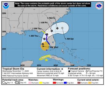
The National Hurricane Center upgraded TS Eta to hurricane status Wednesday morning. SECO Energy has been monitoring Eta and its pending effects on the cooperative’s territory. Hurricane Eta’s track and landfall site have continued to change since the storm moved away from Central America last week. Forecasters now predict Hurricane Eta will make an easterly turn into Florida’s Gulf Coast with the potential to travel through SECO’s service area as a tropical storm.


The National Hurricane Center (NHC) forecasts shows that Hurricane Eta is about 145 miles south/southwest of Tampa with 75 mph sustained winds. On the forecast track, the center of Eta will move closer to the southwest coast of Florida today, approach the west-central coast of Florida tonight, and move inland over the northern portion of the Florida peninsula on Thursday. Eta is expected to move northeastward into the western Atlantic late Thursday or early Friday.


Projected landfall location is between Citrus and Levy Counties. Citrus County has announced school closures for Thursday. Currently, hurricane force winds extend 60 miles from the center. SECO’s forecaster predicts that Eta will bring heavy rains and wind gusts between 40 and 50 mph at peak to parts of the cooperative’s service territory. A storm surge warning has been issued for the Florida west coast from Suwannee River to Bonita Beach, including Tampa Bay and Charlotte Harbor.


cone eta hurricane


SECO Energy is StormReady and prepared to respond to power outages caused by Hurricane Eta’s rainbands and wind gusts. SECO employee and contractor line crews, as well as tree crews are staged across the system. Above normal rains in October have left some areas saturated. Additional rain from Hurricane Eta could cause outages from trees falling into power lines.


Since the COVID-19 pandemic began in mid-March, SECO Energy has taken the necessary precautions to ensure the health and wellbeing of its employees and contractors. SECO’s line crews and contractors are the key to preserving service reliability for the cooperative’s 200,000+ homes and businesses within its service territory. The COVID-19 protections instituted for SECO employees and contractors may slow restoration effort.


CEO Jim Duncan stated, “Our SECO storm watchers have been monitoring Hurricane Eta and its wobbling projected track since early last week. We’ve been lucky in Central Florida that the 2020 hurricane season has had minimal effect on our area. Hurricane Eta looks to change that trend. SECO Energy employees and our line and tree contractor partners are prepared to respond to outages from Hurricane Eta’s heavy rains and winds. The track, intensity and forecast of tropical storms and hurricanes often change, and we will keep members updated so they can be prepared.”


Duncan also reminded members that SECO Energy’s StormCenter outage reporting and communications platform offers outage alerts. He advises, “StormCenter is available for members to report new outages or check the status of an existing outage using their smartphones or tablets 24 hours a day, 7 days a week. Members should also enroll in outage notifications and alerts via email, text or voice message, or all three. An alert is sent when the system recognizes that your service has been interrupted. The alert will include crew status, start time and an estimated restoration time. You’ll also receive a notification when service is restored, and we will include the cause of the outage if it is known at that time.”


Members should visit StormCenter and bookmark the site on their smartphones or tablets. On StormCenter, members can view the outage map, manage notifications, check the status of an existing outage, report an area light issue and more. Stay up to date on weather affecting SECO Energy’s service area, the latest news releases and cooperative updates by “liking” SECO’s Facebook page and “follow” @SECOEnergy on Twitter.


Hurricane Matthew Forecast to Hit Florida as Cat 4

Per the National Hurricane Center’s 8 am forecast, Hurricane Matthew is moving northwest at 12 mph. On this track, Matthew crosses the Bahamas today and approaches Florida’s east coast tonight, strengthening to a category 4 hurricane – which means winds of 130 to 156 mph.


The forecasted path of Matthew remains parallel to Florida’s east coast – but models are mixed as to how close the eye will come to Florida’s shores and where it will head after it passes the state. It is certain that Central Florida residents east of I-75 will experience rain and tropical-storm-force winds.


Poles and lines will go down, and power outages will likely be widespread. Because crews are unable to work safely or raise bucket truck booms in winds over 35 mph, outages will be long in duration if crews cannot respond to outages until winds subside and the storm passes.


SECO encourages its members to report outages using smartphones or tablets at the Storm Center application on our website. It’s easy to report with the last name and house number. Members can contact SECO via Facebook and Twitter and read outage details.


For members less tech savvy, call and talk to a member service rep (or use the prompts to report the outage by phone at 800 732 6141. SECO’s System Operations Center is manned 24/7, and our call centers are also manned 24/7 when severe weather comes through – as will be the case as Hurricane Matthew approaches. Also report downed power lines – call 911 if there is immediate danger.


SECO is Storm Ready. Its emergency response plan determines the restoration priority of each feeder. Essential services like shelters, hospitals, schools and government agencies are the highest priority. Next, linemen work to restore power to large groups of members. Then repairs begin on individual services in less populated areas. All day today, additional line crews and tree trimming contractors are arriving at SECO to be staged for the restoration effort.


Members who need continuous power for medical devices and do not have a back-up source of power must act now. Shelters are open in the SECO area. Contact your county’s emergency operations center (EOC) to find shelter in your area – do not wait.


As a not-for-profit electric cooperative, SECO is dedicated to being members’ first source for accurate storm information.

Tropical Storm Colin Update

Governor Scott has declared a state of emergency for SECO Energy’s service area as Tropical Storm Colin moves into the Central Florida area. A tropical storm warning has been issued for SECO’s entire service territory.


The National Hurricane Center forecast is showing Colin making landfall this evening near the Big Bend and Panhandle area. The impact may cause storm force winds of 39 mph up to 57 mph with possible tornadoes through early Tuesday morning.


Tropical Storm Colin poses a severe threat to the State of Florida and requires timely precautions. SECO members could see heavy rain and gusting winds as Colin move through the state. SECO members should visit www.secoenergy.com to receive updates and report outages.


Kathryn Gloria, Vice President of Corporate Communications and Energy Services is reminding members that SECO is Storm Ready for its members. “SECO is prepared for the almost daily afternoon storms that affect our service area and we are prepared for stronger storms as well. As a not-for-profit electric cooperative, we are dedicated to being our members’ first source for accurate storm information. “Like” SECO’s Facebook page and “follow” us on Twitter to stay updated about storms affecting our members.”


For members who rely on back-up generators during storm season, remember to read and follow all manufacturer’s safety warnings. Learn more about generator safety and preparing for storm season.