StormCenter logo

Archive

September 2024 Sunshine State Stats

In September 2024, the monthly average temperature fell by 1 degree from the previous month, while the rainfall total recorded at Leesburg International Airport (KLEE) increased by 2.2 inches. The month’s average high temperature was 90 degrees, lower than the August average high temperature by 2 degrees. The average low was 75 degrees, just 1 degree lower than in August. The month’s highest temperature reached 94 degrees on September 1 and 18, and the lowest temperature of 71 degrees occurred on September 22.


September temperatures and rainfall


Reported rainfall in September totaled 9.36 inches, 3.6 inches more than “normal,” as stated by WeatherSentry. Measurable rainfall occurred on 16 days, with the 3-day period of September 3, 4, and 5 amounting to 3.88 inches, over one-third of the monthly total. During the three days surrounding Hurricane Helene (9/25 – 27), rainfall totaled only 1.03 inches.  


Thunderstorm activity within a 20-mile radius of Leesburg International Airport decreased by 57% from August. WeatherSentry detected 3,023 cloud-to-ground strikes in September compared to 7,074 in August. Lightning was most active during the first two weeks of September.


Lightning Archive Report – 20-mile radius from Leesburg International Airport (KLEE) 

Data and charts provided by weathersentry.dtn.com 


Early September lightning strikes

Cloud to Ground Lightning  –  September 1-15, 2024 (2937 strikes)


Late September lightning strikes

Cloud to Ground Lightning –  September 16-30, 2024 (86 strikes) 


Historically, thunderstorm activity decreases in Central Florida during fall and winter months, but SECO Energy reminds members that hurricane season is not over. Continue to keep an eye on local weather alerts for tropical storm systems that may develop. Stay connected to SECO’s StormCenter for updates on approaching severe weather, possible outages, and restorations.


October Forecast from The Old Farmer’s Almanac:

The Old Farmer’s Almanac weather outlook for October 2024 predicts sunny and mild conditions during the first two weeks with just a scattered shower or two. Temperatures are predicted to rise somewhat in the second half of the month, with isolated showers amidst mostly sunny skies. The estimated average temperature for October is 76 degrees, and the expected rainfall is 1.5 inches, which is 3 inches below the average for the month. 


Online Energy-Efficiency Tools 

Log into SmartHub to view past bills and consumption charts to check historical usage. If you want help in reducing your energy usage, SECO offers several energy-efficiency tools to help you identify energy wasters. Take the Home Energy Assessment to receive a detailed email tailored to your home’s features and lifestyle. The energy-saving advice will provide low-cost ways to decrease your usage – and your electric bill. 


Use the Energy Estimator to easily calculate the energy consumed by your appliances, lighting, and electronic devices. 


Protect Your Appliances

Power surges are sudden, powerful increases in voltage that can damage or destroy household appliances and electronics. SECO Energy’s Surge Mitigator™ program offers a meter-based surge arrester designed to protect large appliances, such as motors and compressors, by reducing surges at the meter before they enter your home. Members can lease or purchase the Surge MitiGator surge protection program by completing a contact form. 


To easily calculate how much energy your appliances, lighting, electronic devices, and other energy-using items in your home consume, use the Energy Estimator.

SECO Energy Prepares for Potential Impacts of Helene

Helene is forecasted to be a Category 3 Hurricane. SECO Energy is closely monitoring the path and potential impacts of the impending storm system as it develops, preparing to respond quickly and safely should outages occur. 


Crews are fueling up and prepping trucks with all necessary supplies and materials for any outages that may occur as a result of the hurricane. SECO Energy has dedicated staff assigned to monitor the power system and weather on a daily, 24-hour basis. All other employees, including SECO Energy’s Member Services Center, are on high alert and ready to respond to member needs.


SECO Energy urges members to act now to make preparations to remain safe and comfortable in the event of an outage.  


How You Can Prepare:

  • Assemble an emergency kit. It should include at least a three-day supply of water, non-perishable food, medication, first aid supplies, a flashlight, a weather radio, and extra batteries. Include a list of emergency contacts. 
  • Charge your cell phone and have external backup power sources charged.  
  • Develop an evacuation plan in case it’s needed. Communicate the plan to your family. Include pets or livestock in your plan.  
  • Secure outdoor items. Safely store lawn furniture, decorations, toys, garbage cans, and other items that can be brought indoors.  
  • Close windows and doors in the event of high winds. 
  • Fuel up. Fill up your vehicles before the storm, as a loss of power could affect gas stations. 
  • Consider having supplies handy for your propane or charcoal grill. Be sure to grill outdoors in well-ventilated areas for safety.  
  • If you operate a standby generator after a storm, be sure to follow the owner’s manual instructions and safety recommendations. 


Helene’s current location on September 25, 2024. Graphic courtesy of the National Hurricane Center.


StormCenteris SECO Energy’s outage and communications platform for members to view the outage map, report outages, check the status of an existing outage, report an area light malfunction, and enroll in outage communications and alerts via email, text, voice, or all three. Bookmark on your smartphone or tablet to report outages quickly and easily by going to SECOEnergy.com > StormCenter. 


As a reminder, if heavy rains and strong winds lead to downed lines, stay away! Contact with downed lines can be dangerous, even deadly. Report downed power lines to SECO Energy at (800) 732-6141 or call 911 immediately.


SECO Energy’s Hurricane Handbook includes generator safety tips and guidance on how to prepare before, during, and after a storm. It can be found by going to SECO Energy.com > Safety > Hurricane Handbook. 

August 2024 Sunshine State Stats

In August 2024, Central Florida experienced an increase in rainfall and slightly cooler temperatures compared to the previous month. The average high for August was 92degrees, 2 degrees cooler than July, while the average low remained steady at 76 degrees. The average high and low for August matched historical “normal” average temperatures recorded at Leesburg International Airport (KLEE). The highest temperature of the month was recorded on August 27, reaching 96 degrees; the lowest temperature was 71 degrees and recorded on August 17. 


Reported rainfall in August totaled 7.16 inches, 3.05 inches more than in July and 2.47 inches more than August of last year. Measurable rainfall for August began on the 1st and occurred on 18 of 31 days. The rainiest day was during Hurricane Debby on August 5th, when 4.25 inches fell. 


WeatherSentry detected 7,074 cloud-to-ground lightning strikes within a 20-mile radius of Leesburg International Airport in August. The most active period was the first 15 days of the month when lightning struck 5,253 times versus 1,821 times during the last 16 days.


Lightning Archive Report – 20-mile radius from Leesburg International Airport (KLEE) 

Data and charts provided by weathersentry.dtn.com 

Cloud to Ground Lightning  –  August 1 – 15, 2024  (5,253  strikes)  


Cloud to Ground Lightning –  August 16 – 31, 2024  (1,821 strikes)  


Thunderstorms are common in the summer in Central Florida. SECO Energy encourages members to seek shelter promptly if a thunderstorm approaches.


September Forecast from The Old Farmer’s Almanac:

The Old Farmer’s Almanac weather forecast for September 2024 predicts warm temperatures and thunderstorms for the first 13 days. For the latter half of the month, the forecast suggests slightly cooler temperatures with continued thunderstorms in the South and sunshine in the northern regions from September 24-30. 


The estimated average temperature for September is 80 degrees, and the expected rainfall is 9.5 inches, 2 inches above average. 


Stay Informed 

StormCenter is SECO Energy’s outage and communications platform for members to report outages, check the status of an existing outage, and enroll in outage communications and alerts via email, text, voice, or all three. Visit StormCenter today and bookmark it on your smartphone or tablet to report outages quickly and easily. 


Protect Your Appliances 

Power surges are sudden, powerful increases in voltage that can damage or destroy household appliances and electronics. SECO Energy’s Surge Mitigator™ program offers a meter-based surge arrester designed to protect large appliances, such as motors and compressors, by reducing surges at the meter before they enter your home. Members can lease or purchase the Surge MitiGator surge protection program by completing a contact form. 


Hurricane Preparedness 

September is the peak of Hurricane Season! It’s crucial to prepare in advance for any storm. Refer to the SECO Energy Hurricane Handbook available online here, or pick up a printed copy at one of our Member Service Centers.  


Online Energy-Efficiency Tools 

Log into SmartHub to view past bills and consumption charts to check historical usage. If you want help reducing your energy usage, SECO offers several energy-efficiency tools to help you identify energy wasters. Take the Home Energy Assessment to receive a detailed email tailored to your home’s features and lifestyle. The energy-saving advice will provide low-cost ways to decrease your usage – and your electric bill.  


To easily calculate how much energy your appliances, lighting, electronic devices, and other energy-using items in your home consume, use the Energy Estimator.

July 2024 Sunshine State Stats

In July 2024, the average high and low temperatures climbed higher from last month, along with increased lightning and thunderstorms across Central Florida. The month’s average high was 94 degrees, and the low was 76, both temperatures were 1 degree higher than June. The average high for July increased by 2 degrees and the average low was 1 degree higher than the “normal” average temperatures as recorded at Leesburg International Airport (KLEE). The month’s highest temperature was recorded on July 8, touching 97 degrees; the lowest temperature was 72 degrees and occurred on July 19.  

Reported rainfall in July totaled 4.11 inches, 1.66 inches lower than in June and 1.56 inches lower than the “normal” amount for July. Measurable rainfall for July began on the 4th and occurred on 16 of 31 days. The rainiest day was July 19, when 1.02 inches fell.  


WeatherSentry detected 28,330 cloud-to-ground lightning strikes within a 20-mile radius of Leesburg International Airport in July. The most active period was the last 15 days of the month when lightning struck 19,659 times versus 8,671 times during the first 16 days.  


Lightning Archive Report – 20-mile radius from Leesburg International Airport (KLEE) 

Data and charts provided by weathersentry.dtn.com 


Cloud to Ground Lightning – July 1-16, 2024  (8,671 strikes)  


Cloud to Ground Lightning – July 17-31, 2024  (19,659  strikes)  


Thunderstorms are a frequent occurrence in the summer in Central Florida. SECO Energy reminds members to seek shelter promptly if a thunderstorm approaches. 


August Forecast from The Old Farmer’s Almanac:

The Old Farmer’s Almanac  weather forecast for August 2024 predicts warm and mild temperatures with thunderstorms in the north and sunshine in the south the first 6 days, followed by 5 days of isolated thunderstorms, and 8 days of sunny weather in the north and thunderstorms in the south. The forecast projects additional thunderstorms in the south and a hurricane threat for the north between August 25-28, followed by 3 days of sunny and warm conditions. 


The estimated average temperature for August is 85 degrees, and the expected rainfall is 7 inches, 1 inch below average. 


Stay Informed 

StormCenter is SECO Energy’s outage and communications platform for members to report outages, check the status of an existing outage, and enroll in outage communications and alerts via email, text, voice, or all three. Visit StormCenter today and bookmark it on your smartphone or tablet to report outages quickly and easily. 


Protect Your Appliances 

Power surges are sudden, powerful increases in voltage that can damage or destroy household appliances and electronics. SECO Energy’s Surge Mitigator™ program offers a meter-based surge arrester designed to protect large appliances, such as motors and compressors, by reducing surges at the meter before they enter your home. Members can lease or purchase the Surge MitiGator surge protection program by completing a contact form. 


Hurricane Preparedness 

Hurricane Season is now in its third month. It’s crucial to prepare in advance for any storm. Refer to the SECO Energy Hurricane Handbook available online here, or pick up a printed copy at one of our Member Service Centers.  


Online Energy-Efficiency Tools 

Log into SmartHub to view past bills and consumption charts to check historical usage. If you want help reducing your energy usage, SECO offers several energy-efficiency tools to help you identify energy wasters. Take the Home Energy Assessment to receive a detailed email tailored to your home’s features and lifestyle. The energy-saving advice will provide low-cost ways to decrease your usage – and your electric bill.  


To easily calculate how much energy your appliances, lighting, electronic devices, and other energy-using items in your home consume, use the Energy Estimator.

SECO Energy Crews Work Overnight Through Hurricane Debby 

SECO Energy experienced widespread outages overnight, leaving over 10,000 accounts without power across Citrus, Hernando, Lake, Levy, Marion, Pasco, and Sumter counties as Hurricane Debby moved through the Gulf of Mexico. SECO Energy is calling in outside contractors and fellow cooperative personnel to assist in restoration from Hurricane Debby.


SECO Energy crews worked overnight Sunday to restore electric service to homes and businesses that lost power but were forced to temporarily delay restoration efforts due to high winds as formerly Tropical Storm Debby strengthened to hurricane status. It is unsafe to raise truck buckets in winds higher than 35 mph. Fortunately, restoration work has now resumed with subsiding winds. 


The eyewall of Hurricane Debby made landfall early this morning in the Big Bend area near Steinhatchee as a Category 1 storm. As of 5 a.m. Monday, Hurricane Debby had maximum sustained winds of 80 mph and is moving north-northeast at 10 mph. SECO crews are still battling tropical wind conditions, flooding, and high-water areas. The NHC forecast indicates rain and gusty winds will continue in SECO’s service area for most of Monday and into Tuesday. The possibility of tornadoes and flash floods continues. The current National Hurricane Center (NHC) forecast predicts Debby will rapidly weaken as it moves inland across northern Florida and southeastern Georgia later today through Tuesday.


CEO Curtis Wynn encourages members to practice safety as Hurricane Debby linger. Wynn stated, “During storms and power outages, it’s crucial to exercise extreme caution around downed power lines and trees in our area. Always treat any fallen line as if it’s energized and dangerous. To keep your family safe, ensure children stay indoors and away from potential hazards. If you’re without power and decide to use a generator, follow the manufacturer’s safety guidelines. If you experience a medical emergency or other life-threatening hazard, call 911 right away.” 


SECO’s Emergency Restoration Plan determines the system’s restoration priority for each affected feeder. Essential services such as hospitals, shelters, schools, and government agencies are the highest priority. Line repairs that will restore power to large groups of members are next, feeders that serve large commercial services and then individual electric services in less populated areas. 


Florida Governor Ron DeSantis declared a State of Emergency for 54 Florida counties on Thursday, August 1, and added seven additional counties on Friday, August 2. County Emergency Operations Centers (EOCs) in Central Florida are monitoring Hurricane Debby’s impact. For a list of shelters, including general, pet-friendly, and special needs, visit FloridaDisaster.org. SECO members who require continuous electric service to power life-sustaining medical equipment should have a backup power source or relocate to a shelter. Special needs shelters are open in every county SECO serves.   


StormCenter is SECO Energy’s outage and communications platform for members to report outages, check the status of an existing outage, and enroll in outage communications and alerts via email, text, voice, or all three. Visit StormCenter today and bookmark it on your smartphone or tablet to report outages quickly and easily. 


Major weather events can cause extended power outages. SECO Energy reminds members to follow safety protocols when using a generator during a power outage. Generators emit deadly carbon monoxide (CO) that is odorless and colorless. Thousands of people die each year from CO poisoning. Never operate a generator in an enclosed space, including a garage. Always place the generator at least 15 to 20 feet away from your home and never near open windows. 


Before operating a generator, thoroughly read and review the owner’s manual. Never plug a generator directly into an electrical outlet. This current flow is deadly for utility personnel. Keep children away from an operating generator and store fuel in approved containers. Do not smoke while fueling a generator. Always operate a generator in a dry space. If it is raining, use a canopy or cover. SECO Energy’s Hurricane Handbook includes generator safety tips and instructions on preparing before, during, and after a storm. 


“Like” SECO Energy on Facebook and follow @SECOEnergy on X for prize drawings, news releases, and severe weather alerts affecting SECO Energy’s service territory. Manage your outage notification preferences at StormCenter. To see when SECO Energy crews/contractors are working in your area, visit our new System Improvement map. To learn more about SECO Energy as a not-for-profit cooperative, visit SECOEnergy.com>Your Co-op>About. 

SECO Energy Prepares for Potential Tropical Cyclone 4

SECO Energy is preparing for the possibility that Potential Tropical Cyclone 4 will affect parts of its service territory. Forecasts predict the system could develop into a tropical storm and impact Florida as early as Saturday night.


According to the National Hurricane Center (NHC), Potential Tropical Cyclone 4’s current wind speeds are 30 mph, and the system is moving northwest at 16 mph. Potential Tropical Cyclone 4’s track remains uncertain as it approaches Florida. Current modeling suggests the system will remain on a west-northwest path and strengthen over the next 48 hours, potentially developing into a hurricane.


If Potential Tropical Cyclone 4 follows its projected path, SECO Energy members could experience tropical storm conditions and significant rainfall over the weekend and into early next week. Tornados spawned by tropical force winds are also a threat.


Take time today to prepare your family and home. Monitor weather reports and prepare in advance for Potential Tropical Cyclone 4 to make landfall in SECO Energy’s service territory.


StormCenter is SECO Energy’s outage and communications platform for members to report outages, check the status of an existing outage, and enroll in outage communications and alerts via email, text, voice, or all three. Visit StormCenter today and bookmark it on your smartphone or tablet to report outages quickly and easily.


SECO has designed a new Hurricane Handbook to help members prepare before, during, and after a storm. The Hurricane Handbook is available online.


Stay up to date on weather affecting SECO Energy’s service area, the latest news releases, and cooperative updates by “liking” and “following” SECO Energy on Facebook and X.

June 2024 Sunshine State Stats

In June 2024, the average high and low temperatures climbed higher from last month, along with increased rainfall and thunderstorm activity across Central Florida. The month’s average high temperature was 93 degrees, 2 degrees higher than in May. The average low was 75, an increase of 4 degrees. The high and low June average temperatures were 2 degrees higher than the “normal” averages as recorded at Leesburg International Airport (KLEE). The month’s highest temperature of 98 degrees occurred on June 6, 8, and 9; the lowest temperature was recorded on June 2, touching 69 degrees.

June 2024 temperatures and rainfall

Reported rainfall in June totaled 5.77 inches, .83 inches higher than in May, but still .36 inches lower than the “normal” amount for June. Measurable rainfall occurred on 13 of 30 days and did not begin until June 11. The rainiest day was June 28, when 2.48 inches fell. 


WeatherSentry detected 6,777 cloud-to-ground lightning strikes within a 20-mile radius of Leesburg International Airport in June. The most active period was the last 14 days of the month when lightning struck 5535 times versus 1242 times during the first 16 days. 


Lightning Archive Report – 20-mile radius from Leesburg International Airport (KLEE) 

Data and charts provided by weathersentry.dtn.com 


early June 2024 lightning strikes

Cloud to Ground Lightning June 1-16, 2024 (1242 strikes) 


Late June 2024 lightning strikes

Cloud to Ground Lightning – June 17-30, 2024 (5535 strikes) 


Florida residents know that thunderstorm activity is expected to be a mainstay of Central Florida’s summer weather, and SECO Energy reminds members to take shelter quickly if a thunderstorm approaches. Stay connected to SECO’s StormCenter for updates on outages and restoration progress. SECO offers a meter-based surge arrester designed to protect large appliances (motors and compressors) by reducing surges at the meter BEFORE they enter the home. Members can lease or purchase the Surge MitiGator surge protection program by completing a contact form. 


Hurricane Season is now in its second month. It is important to prepare in advance for a storm’s arrival. Please refer to the SECO Energy Hurricane Handbook online here, or pick up a printed copy at one of our Member Service Centers. 


July forecast from The Old Farmer’s Almanac:

The Old Farmer’s Almanac weather forecast for July 2024 is isolated thunderstorms and hot temps in the first 12 days, followed by five days of warm temps and continued storm activity. A three-day break of sunny and warm conditions is projected for June 19-21, and July is expected to conclude with more scattered thunderstorms and hot conditions during the final ten days. 


The estimated average temperature for July is 85 degrees, and the expected rainfall is 6 inches, 1 inch less than the July average.


Online Energy-Efficiency Tools

Log into SmartHub to view past bills and consumption charts to check historical usage. If you want help in reducing your energy usage, SECO offers several energy-efficiency tools to help you identify energy wasters. Take the Home Energy Assessment to receive a detailed email tailored to your home’s features and lifestyle. The energy-saving advice will provide low-cost ways to decrease your usage – and your electric bill. 


To easily calculate how much energy your appliances, lighting, electronic devices, and other energy-using items in your home consume, use the Energy Estimator.

SECO News June 2024

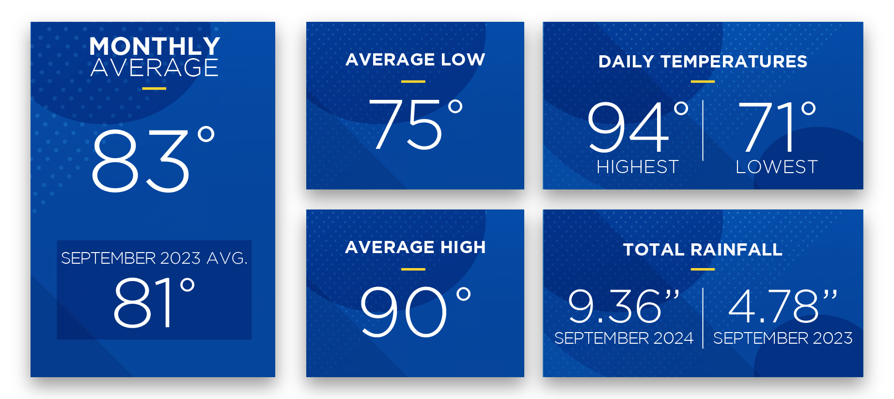
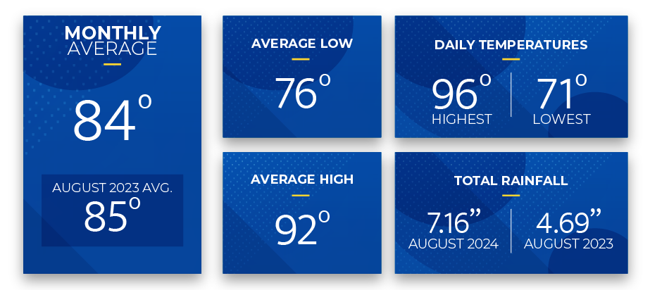
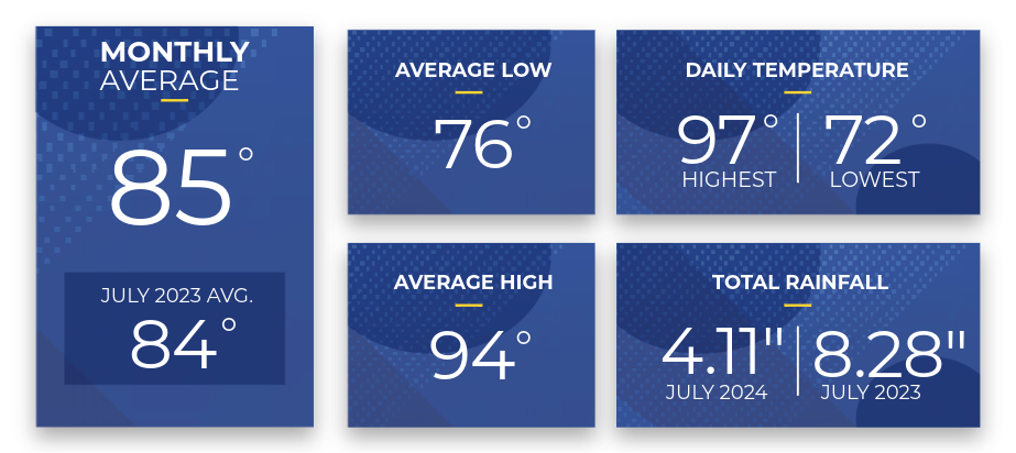
Hurricane Season runs from June 1 to November 30 each year, presenting a heightened risk of severe weather and extended power outages. As the 2024 hurricane season begins, I want to address you directly regarding the forecasted weather patterns for our region and what we are doing to ensure your safety and well-being.


Wynn's Wire


The Colorado State University (CSU) Weather and Climate Research team is predicting an above-average season, with forecasts indicating the possibility of 23 named storms across the Atlantic basin. Eleven are expected to become hurricanes, with five potentially reaching major hurricane status. This projection surpasses the 30-year historical average and reinforces the need for heightened preparedness.


SECO Energy is StormReady and prepared to respond to outages caused by summer thunderstorms, tropical storms, and hurricanes. We closely monitor the weather and make necessary pre-storm preparations behind the scenes. Our crews are trained and ready to respond swiftly to any outages that may occur, but it is equally imperative that all of us take proactive steps to stay prepared.


I strongly urge members to be cautious and prepare for potential disruptions. Essential supplies disappear quickly when tropical storms and hurricanes approach. To ensure you are adequately prepared, stay informed and updated on weather forecasts and advisories issued by state and local authorities. Make time to prepare an emergency kit stocked with essential supplies such as water, non-perishable food, flashlights, batteries, and medications. It’s also important to establish a communication plan with your family and loved ones in case of separation during an emergency. Take precautions to secure outdoor furniture, trim trees, and secure loose objects around your property to minimize potential hazards.


During restoration mode, SECO Energy operates around the clock. Crews on the frontline face elements head-on as they work to clear roads to reach affected areas, repairing broken poles, fallen lines, and damaged equipment. We utilize all available resources to restore power to your homes and businesses as safely and quickly as possible and provide regular updates on our progress to keep you informed every step of the way.


As we embark on this hurricane season, let’s stay vigilant, prepared, and supportive of one another. Your safety and well-being are paramount. Together, we can weather any storm.


Sincerely,


Curtis Wynn

Chief Executive Officer


SECO News June 2024 Portable Generator Dos and Don'ts


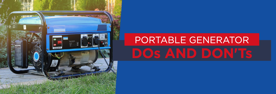
When major storms strike, portable generators can be beneficial but pose significant risks if mishandled. If you plan to use a generator this storm season, here are a few of the dos and don’ts of generator safety you’ll need to know:


  DO:

  • Use generators OUTSIDE ONLY, directing the generator’s exhaust away from your home and any nearby air intakes to other buildings. Deadly levels of carbon monoxide can build up fast from a portable generator’s exhaust.

  • Operate generators on dry surfaces, under open structures, and away from rain and other water sources to minimize electrical hazards. Remember, WATER AND ELECTRICITY DO NOT MIX.


 DON’T:

  • DON’T connect your generator directly to your home’s wiring unless it has been wired for generator use by a licensed electrician.

  • DON’T refuel your generator while it is running. Allow it to cool down before refueling.


Before using a portable generator, always read its operations manual and adhere to its guidelines for safe operation. By following these precautions, you can make the most of your portable generator while keeping you and your loved ones safe.


SECO News June 2024 Safety Before, During, and After a Storm

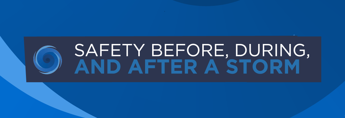
BEFORE: Prepare a storm kit with flashlights, batteries, medicine, first aid supplies, necessary baby items, and supplies for your pets. Stock two weeks’ worth of water, non-perishable food, and essentials. Refill prescriptions and gather important documents such as your social security card, driver’s license, birth certificate, and insurance information for your home, car, and life. Plan an evacuation route in case of an extended power outage and monitor weather forecasts.


DURING: Seek shelter and stay away from windows. Avoid leaving candles unattended and limit opening freezers and refrigerators more than necessary. Turn off your heating and air conditioning systems, and unplug sensitive electronic appliances such as TVs, game consoles, microwaves, and computers – this will protect your appliances against power fluctuations that can occur when power is restored. After power is restored, wait five to ten minutes before turning on appliances and heating systems. Stay updated on local alerts and off roads where trees and power lines are down.


AFTER: Exercise caution if power lines and poles are down; power lines can still be energized even on the ground, so avoid contact. Debris from a storm can hide downed lines and poles. Fallen trees touching energized power lines can electrify nearby objects such as metal fences, ponds, and even the ground. Check your breakers or fuses if power has been restored to your neighborhood but your home remains out. When using a portable generator during an outage, follow the safety tips in the operations manual.


Review our Hurricane Handbook at SECOEnergy.com > Safety > Hurricane Handbook.


SECO News June 2024 A Message from Secretary/Treasurer Morgan Hatfield StormCenter and Area Light Reporting

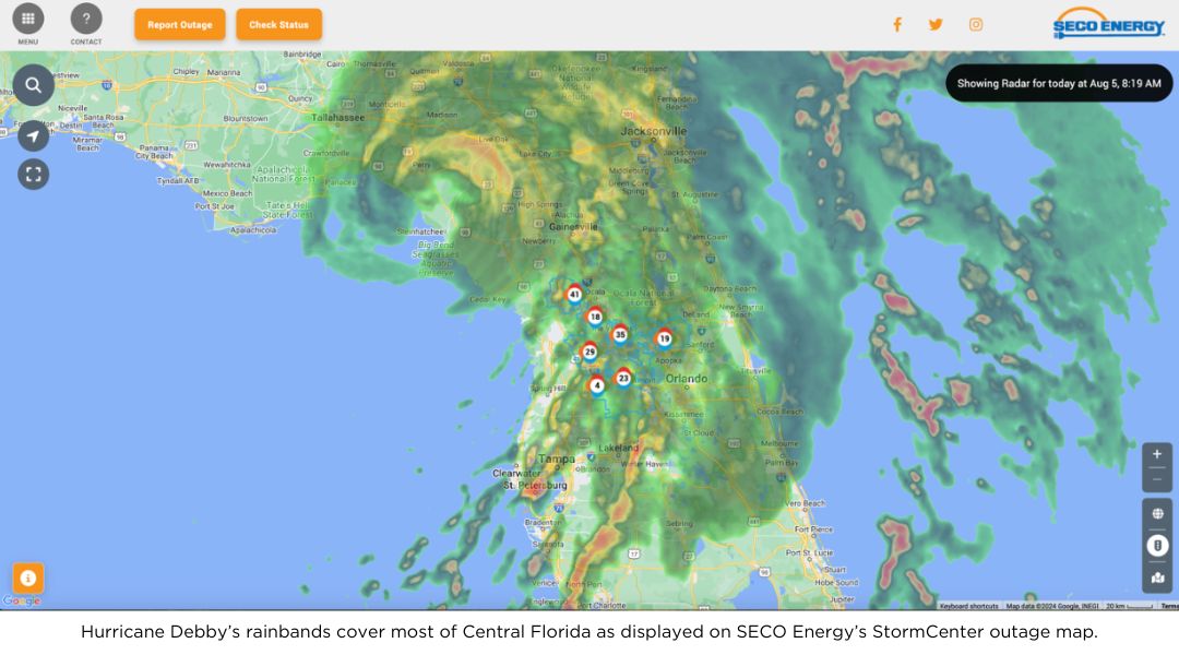
StormCenter is SECO Energy’s outage and communications platform to report outages, check the status of an existing outage, and enroll in outage communications and alerts via email, text, voice, or all three.


Visit SECOEnergy.com > StormCenter and bookmark StormCenter to your smartphone or tablet. With StormCenter bookmarked, you can easily access the outage map, report outages, track restoration progress, and quickly manage notifications related to outage detection and restoration.


You can also report an area light outage or malfunction 24 hours a day, seven days a week, using LightFinder. Simply go to StormCenter’s bookmarked page, choose the LightFinder tile, and enter the pole number or turn on location services to report. Reporting members will receive a follow–up email when the light is repaired – usually within 24 hours.


SECO Energy provides transparent communication and regular restoration updates during storms. Subscribe to receive email, text, and voice notifications on StormCenter. If you have already subscribed, make sure your contact information is up to date to receive timely notifications and updates regarding future outages and restoration efforts.


SECO News June 2024 Medically Necessary Service

SECO Energy strives to provide top-tier reliability to 240,000+ homes and businesses in our service territory. Unexpected outages due to weather, vehicle accidents, equipment issues, trees, or animal contact means that SECO cannot guarantee 100 percent uninterrupted power.


During emergency restoration efforts following widespread damage, SECO Energy’s foremost priority is to restore power to essential facilities such as shelters, hospitals, schools, and government agencies, including emergency operations centers, fire stations, and law enforcement facilities. It’s important to note that residential accounts marked as medically necessary services are not given top priority during emergencies caused by named storms.


For individuals with special needs, resources are available through the Florida Department of Health. Those requiring medical attention or having a specific health need should register with their local emergency management agency to receive assistance during disasters. You can visit FloridaDisaster.org to add your name or a loved one’s to the statewide registry.


Registering provides first responders with valuable information to prepare for disasters or other emergencies to meet citizens’ unique needs. Providing as much information as possible will allow emergency management officials to plan accordingly for future disasters. You will be emailed periodically to verify the information provided is correct and to make any necessary changes.


Unless you plan to seek shelter at an approved facility, backup generation is critical if you are a member who relies on lifesaving medical equipment powered by electricity.


Store your county’s Emergency Operations Center (EOC) contact in your phone for quick access. You can also visit your county’s EOC online and enroll in county-specific emergency assistance services and updates.


CITRUS COUNTY: (352) 249-2775

HERNANDO COUNTY: (352) 754-4083

LAKE COUNTY: (352) 343-9420

LEVY COUNTY: (352) 486-5213

MARION COUNTY: (352) 369-8100

PASCO COUNTY: (727) 847-8137

SUMTER COUNTY: (352) 689-4400


To enroll to receive emergency alerts for your county, visit FloridaDisaster.org.


Read the full June 2024 SECO News.


April 2022 Sunshine State Stats

The weather warmed up in Central Florida in April 2022. The average temperature for the month was 73 degrees, which was 3 degrees warmer than last month’s average. The average high was 83 degrees while the average low was 63 degrees.


Sunshine State Stats April 2022 temps


The highest daily recorded temperature in April was 90 degrees and the lowest was 45 – the highest recorded daily temperature in March 2022 was 89 degrees and the lowest recorded daily temperature was 36. April was a bit dryer than average with 2.26 inches of rainfall – or half an inch lower than the monthly average.


High temperatures reached into the 90s in April 2022. Twenty-four days in the month reached over 80 degrees – with summer approaching, expect daily highs in the 80s, 90s and above. Temperatures at night and early morning are warming up, too. Twenty-five days in the month the low temperature reached into the 60s and 70s.


Atlantic hurricane season begins June 1 and ends November 30. The last seven hurricane seasons have seen a tropical storm or hurricane form in May. Now is the time to begin planning for the upcoming hurricane season. Don’t wait until a storm is approaching our shores to prepare. Read our Hurricane Handbook to learn more about what to do before, during and after a tropical storm or hurricane.


May forecast:


Daily high temperatures will soar over 80 degrees and into the 90s for May 2022. The best chance for rain is early in the month. Members may notice an increase in their April energy usage if they used air conditioning to combat the daily high temperatures during the month.


The Old Farmer’s Almanac predicts a warm May with an average temperature of 76 degrees, which is average for our area. Rainfall is predicted to be above average in May.


To check historical usage, log into SmartHub to view past bills and consumption charts. If your usage is high, SECO offers several energy-efficiency tools to help you identify energy wasters. Take the Home Energy Assessment to receive a detailed email tailored to your home’s features and lifestyle. The energy-saving advice will provide low-cost ways to decrease your usage – and your electric bill.


To easily calculate how much energy your appliances, lighting, electronic devices, and other energy-using items in your home consume, use the Energy Estimator.


Sunshine State Stats May 2020

Summer is almost here in Central Florida and we are feeling the heat. The average monthly temperature in May 2020 was 78.5 degrees only slightly lower than the average monthly temperature of 80.1 degrees in May 2019. The hottest day of the month was on May 22 when temperatures soared to 97 degrees. The lowest temperature recorded was 53 degrees on the evening of May 8.


May 2020 Sunshine State Stats details


May started seasonally with temps mostly in the mid to high 80s; however, in mid-May temperatures began to rise and the average high temperature for the month measured 89 degrees. Central Florida also received more rain near the end of the month with total precipitation at 2.69 inches compared to only 1.22 inches in 2019. Hopefully, your periwinkles are blooming!


On May 4, Governor DeSantis began Phase One of reopening many of Florida’s businesses with safety protocols in place. Thankfully, members started to return to work and leave their homes more often. With summer-like weather arriving early, you may want to schedule an HVAC technician to inspect your cooling system. Annual HVAC maintenance will extend the life of your unit and help you avoid large unexpected repair bills.


For cooling energy-efficiency, adjust your thermostat to between 78 and 80 degrees with the fan in the auto position. If you’re out and about for four hours or more bump your thermostat up a couple of degrees to save. For every degree the thermostat is set below 78 degrees cooling costs increase by 6 to 8 percent.


June 2020 forecast:


Rain is in the forecast for the beginning of June 2020, but temperatures are still predicted to be high. The average temperature for Central Florida for June in 2019 was 82.2 degrees with 5.96 total precipitation for the month. Be sure to use SPF when out in the Florida sun, it is a doozy.


Atlantic hurricane season began on June 1. Forecasters predict an above average hurricane and tropical storm activity this year. SECO Energy is StormReady and offers resources to help you and your family prepare for hurricanes and tropical storms that affect our area. Read our Hurricane Handbook for information before, during and after a storm online.


To check historical usage, log in to SmartHub to view past bills and consumption charts. If your usage is high, SECO offers several energy-efficiency tools to help you identify energy wasters. Take the Home Energy Assessment to receive a detailed email tailored to your home’s features and lifestyle. The energy-saving advice will provide low-cost ways to decrease your usage – and your electric bill.


To easily calculate how much energy your appliances, lighting, electronic devices, and other energy-using items in your home consume, use the Energy Estimator.