StormCenter logo

Archive

August 2023 Sunshine State Stats

In August 2023, the average high and low temperatures rose slightly from July’s figures. The average high temperature rose 2 degrees, to 94, and the average low inched 1 degree higher than July, settling at 76 degrees. Rainfall reported from Leesburg International Airport (KLEE) decreased significantly from the month prior.  


Central Florida escaped much of Hurricane Idalia’s impact, which devastated coastal areas north of SECO Energy’s service territory. While measurable precipitation occurred on only 10 of 31 days, late afternoon thunderstorm activity maintained its presence throughout the month. August 2023 rainfall totaled 4.69 inches, 3.59 inches less than the total rainfall in July. 


August 2023 Sunshine State Stats temps


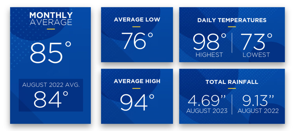
The average temperature for August 2023 was 85 degrees (1 degree higher than last month’s average), yet the daily high temps hit 90 degrees or above on all but one day. The highest daily recorded temperature (data from the Leesburg KLEE weather station) in August was 98 degrees and the lowest was 73 – matching the highest daily recorded temperature in July, and exceeding July’s lowest by 1 degree.   


For most of August, the entire state of Florida was under heat advisories or excessive-heat warnings. As the heat index in many parts of Central Florida topped 110 degrees, on Sunday, August 13, SECO Energy recorded an instantaneous system peak of 984.3 megawatts at 5:00 p.m. This peak load shattered the previous record of 949 set in July 2023. 


HVAC is the largest energy user in Central Florida homes, accounting for an average of 35 to 40% of kWh usage. This next month may be a good time to consider revisiting your thermostat settings to take advantage of savings opportunities presented by moderating temperatures. The energy-efficient thermostat setting during hotter months is 78 degrees and during colder months it is 68 degrees.


What are Cooling/Heating Degree Days? 

Cooling Degree Day (CDD) scores represent the difference between the mean temperature for a given day (the high temp + the low temp, divided by 2) and 65 degrees. A positive number represents a Cooling Degree Day and the higher the number, the further the mean temperature was from 65 degrees. In colder months, there are days where the difference between the mean temperature and 65 degrees is a negative number. This represents a Heating Degree Day (HDD). In August, the monthly CDD score was 628. By contrast, the April 2023 CDD was 292, while there were no HDDs recorded.


September forecast from The Old Farmer’s Almanac:  

The weather outlook for September 2023 indicates a monthly average temperature in the lower 80s with precipitation totals about 2 inches lower than average. Look for scattered showers and a few thunderstorms throughout the month with some noticeable periods of partly cloudy days mixed in. 


The Atlantic hurricane season enters its final two months, and the updated storm predictions from Colorado State University suggest we may still experience an “above-normal season.” Read the details in the September SECO News. 


Online Energy-Efficiency Tools  

Log into SmartHub to view past bills and consumption charts to check historical usage. If your usage is high, SECO offers several energy-efficiency tools to help you identify energy wasters. Take the Home Energy Assessment to receive a detailed email tailored to your home’s features and lifestyle. The energy-saving advice will provide low-cost ways to decrease your usage – and your electric bill. 


To easily calculate how much energy your appliances, lighting, electronic devices, and other energy-using items in your home consume, use the Energy Estimator. 

SECO News September 2023

Wynn's WireDear Members,

I have great news to share with you this month – Hot Bucks are back and reduce the residential bill to the lowest cost in the last five years! SECO Energy is happy to announce a significant reduction on your electric bill.


Hot Bucks (which is known formally as the PCA short for Power Cost Adjustment) will display as a line item on your monthly billing statement. The credit will appear on bills beginning October 1 to reflect prior period usage from September.


SECO’s Hot Bucks are a direct reflection of the price variation the cooperative pays for power purchased from Seminole Electric Cooperative. Natural gas is the main fuel source for power generation and a continued downward trend in price is projected as we move into the latter part of the summer.


Florida utility cost comparisonIn alignment with Seminole’s projections, SECO’s Board of Trustees approved changing the PCA to lower our members’ bills. Both SECO and Seminole are not-for-profit cooperatives that work closely to ensure the lowest rates possible for our members. When the wholesale cost of purchased power decreases, SECO passes those savings along to you.


The Hot Bucks credit will reduce SECO Energy’s cost for residential service per 1,000 kilowatt hours (kWh) from $146.60 to $116.60 with bills generating as of October 1. The chart below compares SECO Energy’s residential cost for 1,000 kilowatt hours (kWh) with other Florida utilities.


This reduction places SECO Energy’s cost per kWh in a competitive position: lower than the average Florida Investor-owned, Municipal and Cooperative utility.


Our Mission, as a not-for-profit cooperative is to provide reliable and innovative energy services to our members and communities. Ensuring affordable energy service is a key component to fulfilling our role as your trusted source for energy solutions.


Best regards,


Curtis Wynn
Chief Executive Officer


SECO News September 2023 Atlantic Hurricane Season Update


We have reached the mid-point of the Atlantic hurricane season (June 1 – November 30). In early April, experts from Colorado State University’s (CSU) Tropical Weather and Climate Research forecast below-average hurricane and tropical storm activity this season.


The outlook has changed in mid-season. CSU is now predicting “above-average” levels of named and major storms with 18 projected this year. Nine of these storms will develop into hurricanes and four will be major hurricanes.


Not only are we faced with the possibility of higher-than-average tropical storm and hurricane activity this year, but CSU experts also predict the probability of a major hurricane making landfall in the United States is above the historical long-term average. As a reminder, a major hurricane is a Category 3-5 with sustained winds of at least 111 mph or greater.


STORM CONDITIONS AT ODDS?

While this forecast creates concern, there are uncertainties as to how two major weather conditions may influence the storm activity we ultimately experience in Florida. The warmer-than- normal Atlantic Ocean waters and a particularly strong El Niño weather pattern are conflicting signals. The El Niño climate pattern often breaks up storms in the Atlantic and tropics, but researchers are unsure if this pattern will continue with the extremely warm ocean waters.


Hurricanes and tropical storms form most often in September, which is why now is a good time to refresh your emergency hurricane supplies if you haven’t done so. At the time of this column printing, this year’s storms include Tropical Storms Arlene, Bret and Cindy formed in June, and Subtropical Storm Don formed in July.


Remain indoors and prepare to wait out the weather safely during a storm. Crews are dispatched to begin restoration only after wind speeds are less than 35 mph. If you shelter away from home, assess your home to make sure it is safe before you return. For homes with damage, turn off your main breaker if it is safe to do so. If appliances are wet, turn off each appliance’s breaker and then unplug. Contact a licensed electrician for repairs.


Most important, focus on your family’s safety. Stock up on hurricane essentials – buy early. When a storm approaches supplies sell out quickly.


The SECO Energy Hurricane Handbook is your one-stop guide to being StormReady before, during and after a storm. Before a storm arrives, bookmark both our outage reporting and notifications platform StormCenter and our Daily Restoration Plan map on your smartphone or tablet. Find these tools at SECOEnergy.com.


SECO News September 2023 Emergency Operations A Message From Board of Trustees Secretary/Treasurer Morgan Hatfield

Visit your county’s EOC website and sign up for alerts from your local Emergency Operations Center (EOC) for resources such as shelter information, storm planning, evacuation orders and more.


To enroll in your county’s emergency alerts, visit www.FloridaDisaster.org. Enter the county or city and follow the enrollment link. Program your county’s number on your phone or bookmark the page in your smartphone for quick access.


MEDICALLY NECESSARY SERVICE AND SPECIAL NEEDS REGISTRY


Through the Florida Department of Health, persons with special needs can register with their local emergency management agency to receive assistance during a disaster. Visit www. FloridaDisaster.org to add your name or a loved one’s to the statewide registry.


Registering provides first responders with valuable information to prepare for disasters or other emergencies to meet citizens’ unique needs. Providing as much information as possible will allow emergency management officials to plan accordingly for future disasters. You will be emailed periodically to verify the information provided is correct and to make any necessary changes.


Unless you plan to seek shelter at an approved facility, back-up generation is critical if you are a member who relies on lifesaving medical equipment powered by electricity.


CITRUS COUNTY: SheriffCitrus.org > Emergency Management or (352) 249-2775

HERNANDO COUNTY: HernandoCounty.us > Departments > Emergency Management or (352) 754-4083

LAKE COUNTY: LakeCountyFL.gov > Services > Emergency Management or (352) 343-9420

SUMTER COUNTY: SumterCountyFL.gov > Government Services > Emergency Management or (352) 689-4400

LEVY COUNTY: LevyDisaster.com or (352) 486-5213

MARION COUNTY: MarionSo.com > Emergency Management or (352) 369-8100

PASCO COUNTY: PascoCountyFL.net > Live > Disaster Preparedness or (727) 847-8137


SECO Stands Storm Ready


Go to SECO Energy’s STORMCENTER to report an outage, check the status of an outage, see the estimated time of restoration, report an area light outage and manage your notifications.

SECO Energy StormCenter


Read the full September 2023 SECO News.

July 2023 Sunshine State Stats

In July 2023, both the average high and low temperatures rose from June’s figures. Rainfall increased nearly 24% from the month prior as Central Florida weather continued its steamy path through summer. While tropical storm formation remained quiet, local rain and thunderstorm activity was busy, and measurable precipitation occurred in 17 out of 31 days. After the first five days of July pushed highs at or above 95 degrees with no rain, a seasonal pattern of afternoon storms became more predictable.


July Leesburg FL weather stats


While the average temperature for July 2023 was 84 degrees (3 degrees higher than last month’s average), there is no denying that the month was boiling hot. There are claims that this may be the hottest month ever recorded. Heat indices soared to 110 degrees in some parts of Central Florida and even reached the 120-degree mark in South Florida and other states. The average high was 92 degrees, while the average low was 75 degrees.


With steady temperatures in the hot to boiling range, members’ kilowatt-hour (kWh) usage has likely increased as they utilize their HVAC use to combat rising summer temperatures. HVAC is the largest energy user in Central Florida homes – accounting for 35 to 40% of kWh usage on average. Read August SECO News for advice on a summer HVAC tune up.


The highest daily recorded temperature (data from the Leesburg KLEE weather station) in July was 98 degrees and the lowest was 72 – the highest daily recorded temperature in June was 96 degrees and the lowest was 66. July 2023 rainfall totaled 8.28 inches, versus 6.75 inches in June. Precipitation was most active in the second and third weeks.


August forecast from The Old Farmer’s Almanac


Look for isolated showers and scattered thunderstorms throughout the month and 2” lower-than-average rainfall. Temperatures will begin to moderate toward the end of the month resulting in a projected average temperature of 83 degrees.


The Atlantic hurricane season enters its third month, and some storm predictions are shifting. Colorado State University released a mid-season projection that now suggests we may experience an “above-normal season” with 18 named storms, nine of which may become hurricanes, and of those nine, four could becoming major, Category 3,4, 5 storms.


Keep your eyes on the tropics for early signs of disturbances that could strengthen and impact Florida. Now is the time to gather your hurricane/emergency supplies. Review our Hurricane Handbook for a list of supplies, and what actions to take before, during and after a storm. Remember, supplies sell out quickly once a storm is forecast to affect our area.


To check historical usage, log into SmartHub to view past bills and consumption charts. If your usage is high, SECO offers several energy-efficiency tools to help you identify energy wasters. Take the Home Energy Assessment to receive a detailed email tailored to your home’s features and lifestyle. The energy-saving advice will provide low-cost ways to decrease your usage – and your electric bill.


To easily calculate how much energy your appliances, lighting, electronic devices, and other energy-using items in your home consume, use the Energy Estimator.