StormCenter logo

Archive

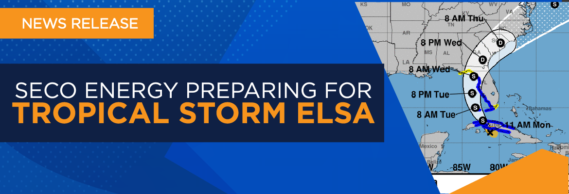
SECO Energy Preparing for Tropical Storm Elsa

SECO Energy continues its preparations for Tropical Storm Elsa and the weather effects this storm will bring to its service area. Tropical Storm Elsa looks poised to make landfall at Cedar Key on Florida’s Gulf Coast sometime Tuesday evening.


The current forecast from the National Hurricane Center (NHC) shows Tropical Storm Elsa with maximum sustained winds up to 65 mph. The storm has stalled over western Cuba and has slowed to 14 mph as it moves northwest. Elsa’s tropical storm-force winds extend 75 miles from the center. There is still the potential for Tropical Storm Elsa to intensify as it moves past Cuba and into the Gulf of Mexico. The storm’s eventual landfall, final track and intensity continue to remain uncertain.


SECO members should be prepared for heavy rain from Tropical Storm Elsa beginning late Tuesday afternoon and lasting through Wednesday. The area along I-75 and west to the Gulf Coast will likely feel the most impact from Elsa. The wind speed is forecast to be sustained at 18 to 20 mph and wind gusts of 25 to 35 mph. The grounds are already heavily soaked after a rainy June. More rain could bring trees down and create extended power outages.


CEO Jim Duncan urges members to remain vigilant for Tropical Storm Elsa. He stated, “Tropical Storm Elsa has the potential to pick up speed, intensity and develop into a bigger storm. Don’t be caught off guard. Continue to follow the storm’s forecast, prepare your families, secure your homes and have your emergency supplies available and easily accessible. Members close to the west coast should be especially cautious.”


Duncan also reminded members that SECO Energy’s StormCenter outage reporting and communications platform offers outage alerts. “StormCenter is available for members to report outages using their smartphones or tablets 24 hours a day, 7 days a week. Members should also enroll in outage notifications and alerts via email, text, voice message, or all three. An alert is sent when the system recognizes that your service has been interrupted. The alert will include crew status and an estimated restoration time. You’ll also receive a notification when the service is restored that includes the cause of the outage if it is known at that time.”


Members should visit StormCenter and bookmark the site on their smartphones or tablets. At StormCenter, members can view the outage map, enroll or manage notifications, check the status of an existing outage, report an area light outage and more.


Stay up to date on weather affecting SECO Energy’s service area, the latest news releases and cooperative updates by liking SECO’s Facebook page and following @SECOEnergy on Twitter.

Tropical Storm Eta Hits Citrus & Sumter in SECO Energy Territory

Overnight, several thousand SECO Energy members largely in Citrus and Sumter Counties were affected by Tropical Storm Eta-related outages. Line and tree crews worked throughout the night to restore service. Currently, the service territory has 88 outage events reported – affecting nearly 1,900 members. The local Central Florida forecast indicates that wind and rainbands will continue to affect the SECO service territory through early afternoon Thursday.


When assessing your property, stay away from downed power lines and report them to SECO immediately. Call 911 if there is immediate danger. Always assume a downed line is energized even if power is out at your location. Lake, Marion, Citrus and Sumter County schools are closed today, so ensure that your children understand this dire safety rule about staying away from downed lines.


According to the National Hurricane Center (NHC), Tropical Storm Eta made its fourth landfall around 4 a.m. Thursday morning near Cedar Key on Florida’s Gulf Coast. The storm hit with maximum sustained winds of 50 mph. Earlier this week, Governor Ron DeSantis expanded the state of emergency to include Citrus, Levy, Marion and Sumter Counties in SECO’s service area.


CEO Jim Duncan stated, “We are thankful that Tropical Storm Eta is passing through our system with minimal damage to our infrastructure. Members should continue to be on alert for the final rainbands passing through our service area through early afternoon and should report outages immediately through StormCenter. Crews will continue to work until all members’ services have been restored.”


SECO Energy’s online outage reporting and communications platform StormCenter is available 24/7 to report new outages or check the status of an existing outage. Members can use their smartphones or tablets to report outages, enroll in outage notifications and alerts via email, text or voice message, or all three. An alert is sent when the system recognizes that your service has been interrupted. The alert will include crew status, start time and an estimated restoration time.


Members can visit StormCenter and bookmark the site on their smartphones or tablets. On StormCenter, members can view the outage map, manage notifications, check the status of an existing outage, report an area light issue and more.


Stay up to date on weather affecting SECO Energy’s service area, the latest news releases and cooperative updates by “liking” SECO’s Facebook page and “follow” @SECOEnergy on Twitter.

SECO Energy Tracking Tropical Storm Eta

SECO Energy is tracking Tropical Storm Eta and the possibility of a late-season tropical storm event for Central Florida. While Tropical Storm Eta’s eventual track and possible Florida landfall remain uncertain, SECO is prepared for the weather effects this storm could bring to its service area.


The National Hurricane Center (NHC) forecasts that Tropical Storm Eta will bring rain and winds to Central Florida next week. Eta weakened while over Central America. Forecasts predict the storm will take a northeastern turn and may gain strength. The probable track shows Tropical Storm Eta traveling across Cuba on its way toward Florida.


SECO members should prepare for the possibility of rain and winds early next week. SECO’s service area could begin to feel the effects of Tropical Storm Eta on Monday. Above normal rains in October have left some areas saturated. Additional rain from Tropical Storm Eta could cause outages from trees falling into power lines.


Since the COVID-19 pandemic began in mid-March, SECO Energy has taken the necessary precautions to ensure the health and wellbeing of its employees and contractors. SECO’s line crews and contractors are the key to preserving service reliability for the cooperative’s 200,000+ homes and businesses within its service territory. The COVID-19 protections instituted for SECO employees and contractors may slow restoration effort.


CEO Jim Duncan stated, “At times, Mother Nature likes to remind us that hurricane season lasts through the end of November. A late-season storm such as Tropical Storm Eta is a good reminder to stay vigilant during the entire hurricane season. Make sure your hurricane supplies are well stocked and up to date. We are watching Tropical Storm Eta closely, and SECO crews and contractors will be prepared to restore outages if needed in our area.”


Duncan also reminded members that SECO Energy’s StormCenter outage reporting and communications platform offers outage alerts. He advises, “StormCenter is available for members to report outages using their smartphones or tablets 24 hours a day, 7 days a week. Members should also enroll in outage notifications and alerts via email, text or voice message, or all three. An alert is sent when the system recognizes that your service has been interrupted. The alert will include crew status and an estimated restoration time. You’ll also receive a notification when service is restored, and we will include the cause of the outage if it is known at that time.”


Members should visit StormCenter and bookmark the site on their smartphones or tablets. On StormCenter, members can view the outage map, enroll or manage notifications, check the status of an existing outage, report an area light issue and more.


Stay up to date on weather affecting SECO Energy’s service area, the latest news releases and cooperative updates by “liking” SECO’s Facebook page and “follow” @SECOEnergy on Twitter.

Sunshine State Stats August 2020

August in Central Florida was hot! The average high temperature was a melting 92 degrees while the average low was a warm 76 degrees. The average temperature for the month was 84. The highest recorded temperature was 96 degrees and the lowest recorded temperature was 73 degrees.


August 2020 Sunshine State Stats temperature breakdown


August was hot and drier than average. The average rainfall amount in August in Central Florida is 6.2 inches. In August 2020, rainfall was substantially lower than average at only 5.76 inches. Rainfall in August 2019 was much higher than average at 8.42 inches.


Hurricane activity and Accumulated Cyclone Energy (ACE) has been higher this year per the National Oceanic and Atmospheric Administration (NOAA). Tropical Storm Josephine, Tropical Storm Kyle, Hurricane Laura, Hurricane Marco, Tropical Storm Omar and Hurricane Nana all formed in August 2020.


Is your hurricane supplies kit ready for the possibility of a tropical storm or hurricane? We recommend having a three-day supply of non-perishable food and water per person, along with a seven-day supply of medications. Other essentials include a weather radio, cash, flashlights, batteries, can opener, and a first-aid kit. You will find a list of hurricane essentials on our Storm Preparation page.


September forecast:


September is the peak of Atlantic hurricane season. Read our special Hurricane Handbook edition of SECO News to prepare before, during and after a storm. September weather is similar to August. Temperatures normally average 83.8 degrees with precipitation just over 6 inches.


To check historical usage, log into SmartHub to view past bills and consumption charts. If your usage is high, SECO offers several energy-efficiency tools to help you identify energy wasters. Take the Home Energy Assessment to receive a detailed email tailored to your home’s features and lifestyle. The energy-saving advice will provide low-cost ways to decrease your usage – and your electric bill.


To easily calculate how much energy your appliances, lighting, electronic devices, and other energy-using items in your home consume, use the Energy Estimator.


*source: www.nhc.noaa.gov

SECO Energy Monitoring Tropical Storm Isaias

SECO Energy continues to monitor Tropical Storm Isaias as it moves along Florida’s east coast. The storm was downgraded from a Category 1 hurricane to a tropical storm early Sunday morning. The current track brings the storm close to Jupiter and Melbourne.


The National Hurricane Center (NHC) forecasts that Tropical Storm Isaias will no longer make landfall along Florida’s east coast. The storm is moving northwest and has slowed to 8 mph with wind speeds at 60 mph. Forecasters predict that the storm will travel along Florida’s east coast toward the Carolinas. Tropical Storm Isaias will bring rain to the east coast from Florida to Maine.


Forecasters predict SECO’s service area could begin to feel the effects of Tropical Storm Isaias early Sunday afternoon into the early hours Monday morning. Members should expect wind gusts and heavy rains as Isaias’ rainbands move through the state. The strongest winds will affect SECO’s area beginning Sunday evening into the early hours Monday morning. The maximum sustained winds are expected to be upwards of 20 mph in eastern Marion County and Lake County with gusts up to 40 mph. Western Marion County, Citrus and Sumter Counties will have sustained winds at 18 mph with gusts up to 30 mph.


Since the COVID-19 pandemic began in mid-March, SECO Energy has taken the necessary precautions to ensure the health and wellbeing of its employees and contractors. SECO’s line crews and contractors are the key to preserving service reliability for the more than 200,000 homes and businesses the cooperative serves. The COVID-19 protections instituted for SECO employees and contractors could delay the restoration effort.


CEO Jim Duncan said, “Thankfully, Isaias has lost strength and is now a tropical storm instead of a hurricane. Nonetheless, SECO is ready for Isaias and its effects on our service area. We are warning members in Lake and Marion Counties to be prepared for heavy rains, winds and the possibility of power outages because of Isaias’ track through the state. Employees are ready to respond to outages. We will work until all members’ services are restored.”


Duncan also reminded members that SECO Energy’s StormCenter outage reporting and communications platform offers outage alerts. “StormCenter is available for members to report outages using their smartphones or tablets 24 hours a day, 7 days a week. Members should also enroll in outage notifications and alerts via email, text or voice message, or all three. An alert is sent when the system recognizes that your service has been interrupted. The alert will include crew status and an estimated restoration time. You’ll also receive a notification when the service is restored, and we will include the cause of the outage if it is known at that time.”


Members should visit StormCenter and bookmark the site on their smartphones or tablets. On StormCenter, members can view the outage map, enroll or manage your notifications, check the status of an existing outage, report an area light outage and more.


Stay up to date on weather affecting SECO Energy’s service area, the latest news releases and cooperative updates by “liking” SECO’s Facebook page and “follow” @SECOEnergy on Twitter.

SECO Energy Prepared for Hurricane Isaias

SECO Energy is prepared for Hurricane Isaias as its projected track shifts east, tracking the storm slightly farther away from Florida’s east coast. Currently, Hurricane Isaias is a Category 1 storm with winds up to 85 mph.


The National Hurricane Center (NHC) forecasts that the storm will likely travel along Florida’s east coast toward the Carolinas. Isaias is moving northwest at 15 mph. Hurricane-force winds extend outward from the storm’s eye up to 35 miles. Tropical-storm force winds extend from the center up to 175 miles. The final track and intensity of Isaias remain uncertain, and the NHC has not ruled out a Florida landfall.


Forecasters predict SECO’s service area could begin to feel the effects of Hurricane Isaias as early as late morning on Sunday through the evening. Members should expect heavy rains for at least 24 hours and sustained winds in the 10 to 25 mph range with gusts up to 40 mph. The higher wind speeds are expected in SECO’s eastern part of its territory.


Since the COVID-19 pandemic began in mid-March, SECO Energy has taken the necessary precautions to ensure the health and wellbeing of its employees and contractors. SECO’s line crews and contractors are the key to preserving service reliability for the more than 200,000 homes and businesses the cooperative serves. The COVID-19 protections instituted for SECO employees and contractors could delay the restoration effort.


CEO Jim Duncan said, “SECO and its employees are prepared for Hurricane Isaias’ effect on our service area. We expect that members in the eastern part of our service area, particularly Lake County, will experience power outages from the heavy rains, wind gusts and lightning. Employees are on stand-by and ready to respond to outages. We will work until all members’ services are restored.”


Duncan also reminded members that SECO Energy’s StormCenter outage reporting and communications platform offers outage alerts. “StormCenter is available for members to report outages using their smartphones or tablets 24 hours a day, 7 days a week. Members should also enroll in outage notifications and alerts via email, text or voice message, or all three. An alert is sent when the system recognizes that your service has been interrupted. The alert will include crew status and an estimated restoration time. You’ll also receive a notification when the service is restored, and we will include the cause of the outage if it is known at that time.”


Members should StormCenter and bookmark the site on their smartphones or tablets. On StormCenter, members can view the outage map, enroll or manage your notifications, check the status of an existing outage, report an area light outage and more.


Stay up to date on weather affecting SECO Energy’s service area, the latest news releases and cooperative updates by “liking” SECO’s Facebook page and “follow” @SECOEnergy on Twitter.

Hurricane Dorian Rain Bands Lash SECO Energy Area

Hurricane Dorian’s outer rain bands lashed the eastern portion of SECO Energy’s service area overnight Tuesday and continue into Wednesday. SECO’s electric system fared well during wind gusts that topped a reported 40 mph.


Hurricane Dorian is hovering off Florida’s east coast this morning as a CAT 2 hurricane with maximum sustained wind speeds at 105 mph. Dorian is moving north-northwest at 8 mph. SECO members can expect Hurricane Dorian’s outer bands to dump more rain on the already saturated ground. Dorian’s rain bands are forecast to clear SECO Energy’s service territory later tonight. For the remainder of the day SECO members located east of I-75 can expect rain bands, isolated lightning and wind gusts up to 40 mph.


September is typically the peak of Atlantic hurricane season. According to the National Hurricane Center, as of early Wednesday morning there are five active Atlantic tropical cyclones and disturbances. SECO Energy’s new Hurricane Handbook is available on SECOEnergy.com by clicking on the homepage banner. The Hurricane Handbook is a member guide for preparing before, during and after a storm. The cooperative has included tips on generator safety, restoration priorities, downed power line safety, electric system 101, Florida’s Move Over Law and more.


CEO Jim Duncan stated, “SECO Energy’s service area will most likely experience a rainy Wednesday while Hurricane Dorian moves away from Central Florida. Overnight, crews responded to a handful of outages. In fact, as of this morning less than 100 members experienced an outage caused by Dorian. The hurricane’s rain and wind bands haven’t cleared out of our system yet, outages caused by lightning, heavy rains and falling trees may still occur.”


Duncan added, “The 2019 Atlantic hurricane season is far from over. Hurricane Dorian was a timely reminder that Floridians need to prepare for tropical storms and hurricanes that affect our area. Read the Hurricane Handbook, keep your supplies updated and continue to watch local weather reports.”


StormCenter is SECO Energy’s outage and communications platform for members to report outages, check the status of an existing outage and enroll in outage communications and alerts via email, text, voice or all three. Visit StormCenter online and bookmark on your smartphone or tablet to report outages quickly and easily.


Stay up to date on weather affecting SECO Energy’s service area, the latest news releases and cooperative updates by “liking” SECO’s Facebook page and “follow” @SECOEnergy on Twitter.

Test Generators Today for Safe Operation Next Week

SECO Energy continues to monitor Hurricane Dorian’s uncertain track as it nears the Florida peninsula. Hurricane Dorian is now a Category 4 hurricane, but its track shifted to the east overnight. Forecasters predict Dorian may not make a Florida landfall. Instead it may travel along Florida’s east coast as a powerful CAT 3 or 4 hurricane, but hurricane-force winds extend for 30 miles and tropical storm force winds extend 105 miles. Even an off-coast path of a CAT 3 or 4 hurricane will impact SECO’s service territory – likely on Tuesday evening into Wednesday.


Major weather events often cause extended power outages. SECO Energy asks members using a generator to operate the equipment in a manner that promotes safety for yourself, SECO employees, its contractors and the public. Generators emit deadly carbon monoxide (CO) that is odorless and colorless. Thousands of people die each year from CO poisoning. Never operate a generator in an enclosed space including a garage. Always place the generator at least 15 to 20 feet away from your home and never in proximity to open windows.


Before operating a generator, thoroughly read and review the owner’s manual. Never plug a generator directly into an electrical outlet. This current flow is deadly for utility personnel. Keep children away from an operating generator and store fuel in approved containers. Do not smoke while fueling a generator. Always operate a generator in a dry space. If it is raining, use a canopy or cover. Test it today before the wind and rain hit next week. SECO Energy’s new Hurricane Handbook includes generator safety tips and preparation for before, during and after a storm.


CEO Jim Duncan warns members to remain vigilant. Duncan stated, “Hurricane Dorian’s track has shifted slightly to the east; however, SECO Energy’s service area will experience the effects of Dorian. Members should prepare for tropical-storm force winds and more rain in an already wet summer. Saturated ground will cause trees to fall on lines and may topple poles. Stay away from downed lines. Our members should prepare for the possibility of widespread and lengthy outages. If Dorian does not stay further offshore, we expect that damage may be significant and the restoration process lengthy.”


StormCenter is SECO Energy’s outage and communications platform for members to report outages, check the status of an existing outage and enroll in outage communications and alerts via email, text, voice or all three. Visit StormCenter today and bookmark on your smartphone or tablet to report outages quickly and easily. Once the hurricane has passed SECO’s area later next week, members should use our Daily Restoration Plan Map to identify if crews are working in their area that day. Click on the homepage banner to access the map.


Stay up to date on weather affecting SECO Energy’s service area, the latest news releases and cooperative updates by “liking” SECO’s Facebook page and “follow” @SECOEnergy on Twitter.

SECO Energy Tracking Hurricane Dorian

SECO Energy is tracking Hurricane Dorian as it travels through the Atlantic toward Florida. Forecasters predict Dorian could increase to a CAT 3 or higher hurricane as it makes landfall on Florida’s east coast Monday evening into Tuesday morning.


During a major weather event with widespread damage and lengthy outage times, members often question restoration priorities. Utilities are required to first restore power to shelters, hospitals, schools and government agencies like emergency operations centers, fire stations, and law enforcement facilities. The next priority is large commercial accounts that provide food, water and damage-recovery supplies. After these priorities, SECO focuses on restoring the highest volume of members as quickly and safely as possible. Distribution feeders with the highest number of members served are first. Feeders with lower member counts and lateral lines in sparsely populated areas are last to be restored.


Members who require uninterrupted electricity to power life-sustaining devices are urged to have a back-up source for power or make arrangements to go to a shelter. Enroll in the Florida Special Needs Registry by visiting floridadisaster.org. Members should also sign up for county alerts (Alert Citrus, Alert Hernando, Alert Lake, Alert Levy, Alert Marion, Alert Pasco and Alert Sumter). Review SECO Energy’s Hurricane Handbook for preparation tips for before, during and after a storm.


CEO Jim Duncan warns members to prepare for power outages from Hurricane Dorian. Duncan stated, “Hurricane Dorian is shaping up to be a very powerful Category 3 or higher hurricane at landfall. The track indicates that Dorian will travel directly over SECO Energy’s service area. Forecasters are still unsure how long the storm will linger over Florida. Prepare for widespread and lengthy power outages. Even with hundreds of additional contractors coming to engage in emergency restoration, the damage will likely be significant and the restoration process lengthy.”


SECO Energy is watching the progress of Hurricane Dorian as it makes its way closer to a Florida landfall. Forecasters predict that Dorian will make landfall as a CAT 3 or higher hurricane. According to the National Hurricane Center (NHC), Dorian’s current sustained wind speeds are 110 mph and the system continues to move northwest at 12 mph. In less than 24 hours, Hurricane Dorian’s maximum sustained wind speeds increased 25 mph and is predicted to increase.


Models shifted to predict landfall closer to south Florida. The Bahama islands are currently under a Hurricane Watch. The likelihood of Hurricane Dorian impacting SECO Energy’s service territory is high.


Florida Governor Ron DeSantis declared a state of emergency at 5 p.m. on Wednesday, August 28. County Emergency Operations Centers (EOCs) in Citrus, Lake, Marion and Sumter County are monitoring Hurricane Dorian’s impact as well. Sandbag locations have been established in Lake and Marion County. Lake and Marion County have executed a local state of emergency.


StormCenter is SECO Energy’s outage and communications platform for members to report outages, check the status of an existing outage and enroll in outage communications and alerts via email, text, voice or all three. Visit StormCenter today and bookmark on your smartphone or tablet to report outages quickly and easily. Once the hurricane has passed SECO’s area later next week, members should use our Daily Restoration Plan Map to identify if crews are working in their area that day. Visit SECOEnergy.com and click on the home page banner to access the map.


Stay up to date on weather affecting SECO Energy’s service area, the latest news releases and cooperative updates by “liking” SECO’s Facebook page and “follow” @SECOEnergy on Twitter.

SECO Energy Preparing for Tropical Storm Dorian

SECO Energy is preparing for the possibility that Tropical Storm Dorian will affect parts of its service territory. Forecasters predict Tropical Storm Dorian could make an east coast Florida landfall as early as late Sunday night and reach hurricane strength while traveling through the Atlantic Ocean.


According to the National Hurricane Center (NHC), Dorian’s current wind speeds are 60 mph and the system is moving northwest at 13 mph. The storm’s eye is predicted to travel across Puerto Rico on Thursday.


The models remain uncertain as to Dorian’s track as it approaches Florida. Current modeling suggests Dorian will remain on a northwestern path, drifting north along the coast before turning into Florida to make landfall near Daytona Beach or Jacksonville late Sunday night into early Monday morning. Tropical Storm Dorian could strengthen to a Category 2 or 3 hurricane before landfall. Predictions will continue to change after Dorian exits Puerto Rico on Friday.


SECO members will likely feel the effects of Tropical Storm Dorian Sunday evening into Monday. If Dorian strengthens over the warm Atlantic waters and takes a Florida turn, SECO members could experience tropical storm force winds and rain on Sunday and Monday. Tornadoes brewing from the tropical storm or hurricane force winds is a threat as well.


CEO Jim Duncan urges members to prepare for Dorian. Duncan stated, “Tropical Storm Dorian could impact SECO members as early as Sunday evening. Even though the models are still uncertain of Dorian’s ultimate path, take the time today and tomorrow to prepare your family and home for this storm. Watch the weather reports, prepare in advance for Dorian to make landfall in Florida and possibly strengthen to a hurricane.”


StormCenter is SECO Energy’s outage and communications platform for members to report outages, check the status of an existing outage and enroll in outage communications and alerts via email, text, voice or all three. Visit StormCenter today and bookmark on your smartphone or tablet to report outages quickly and easily.


SECO has designed a new Hurricane Handbook to help members prepare before, during and after a storm. The Hurricane Handbook is available online.


Stay up to date on weather affecting SECO Energy’s service area, the latest news releases and cooperative updates by “liking” SECO’s Facebook page and “follow” @SECOEnergy on Twitter.