StormCenter logo

Archive

September 2022 Sunshine State Stats

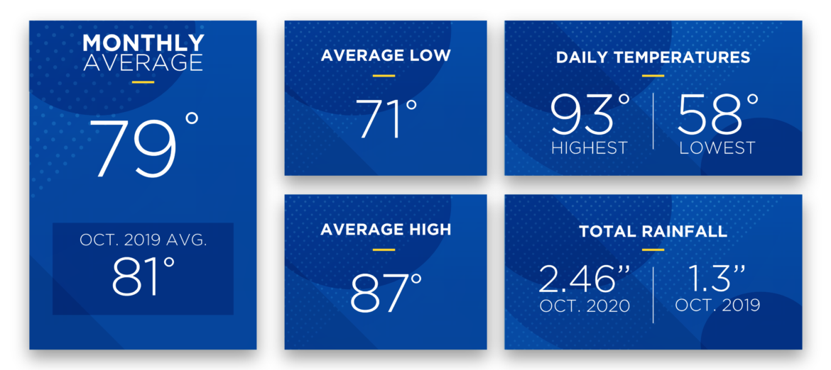
Hurricane Ian blazed through Central Florida between Wednesday, September 28, and Thursday, September 29, bringing large amounts of rainfall, high winds and fall temperatures. The average temperature for the month was 81 degrees, which was 3 degrees lower than last month’s average. The average high was 88 degrees while the average low was 73 degrees.


September 2022 Sunshine State Stats temps


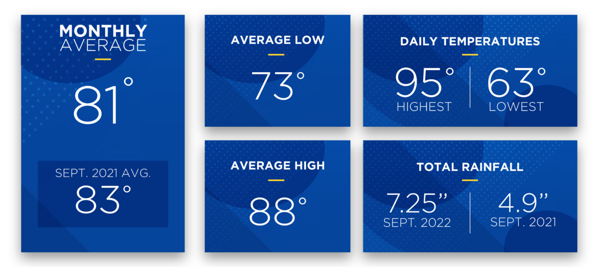
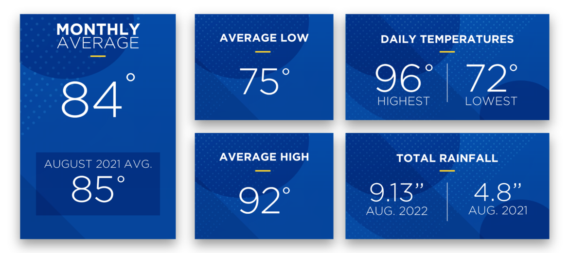
The highest daily recorded temperature (data from the Leesburg KLEE weather station) in September was 95 degrees and the lowest 63 – the highest daily recorded temperature in August 2022 was 96 degrees and the lowest was 72. Rainfall was above average in September. The total precipitation for the month was 7.25 inches, well above the September average rainfall of 5.76 inches.


Daily high temperatures soared over 90 degrees 16 days in September. Hurricane Ian brought a slight cooldown to daily temperatures toward the end of the month. Expect daily highs to reach near 90 degrees into October.


Before September, the 2022 Atlantic hurricane season was mostly inactive. Hurricane Ian made landfall as a strong Category 4 hurricane on Florida’s west coast. It traveled slowly through southwest and central Florida before exiting into the Atlantic and making another landfall in South Carolina. Hurricane Ian was deadly and caused power outages for millions in the southeast United States. At its peak, SECO Energy had just over 11,000 accounts without electric service overnight on the 28th and 29th. All accounts were restored by late on Friday, September 30. It only takes one powerful storm to damage electric transmission and distribution infrastructure causing widespread power outages.


Have a plan in place for hurricane season. Don’t wait until a storm is approaching to prepare. Essential supplies such as water, gasoline, bread and other non-perishable food sell out quickly. Read our Hurricane Handbook to learn more about what to do before, during and after a tropical storm or hurricane.


October forecast:


Expect daily high temperatures to reach into the high to mid 80s during October 2022. Be alert for late-season tropical storm and hurricane activity heading toward Central Florida. Central Florida’s rainy season is winding down, expect less rain and thunderstorms during the month.


HVAC use may be starting to decrease with cooler daily and evening temperatures. For Floridians, HVAC use is a longer span (typically early spring to late fall) than in other parts of the country and runs more frequently. It is likely the highest energy user in your home. Before winter temperatures set in, schedule an HVAC tune up with a qualified technician.


To check historical usage, log into SmartHub to view past bills and consumption charts. If your usage is high, SECO offers several energy-efficiency tools to help you identify energy wasters. Take the Home Energy Assessment to receive a detailed email tailored to your home’s features and lifestyle. The energy-saving advice will provide low-cost ways to decrease your usage – and your electric bill.


To easily calculate how much energy your appliances, lighting, electronic devices, and other energy-using items in your home consume, use the Energy Estimator.


August 2022 Sunshine State Stats

Central Florida was treated to hot days, rainy afternoons and muggy evenings in August 2022. The average temperature for the month was 84 degrees, which was the same as last month’s average. The average high was 92 degrees while the average low was 75 degrees.


SECO Energy August 2022 Sunshine State Stats temps


The highest daily recorded temperature (data from the Leesburg KLEE weather station) in August was 96 degrees and the lowest 72 – the highest daily recorded temperature in July 2022 was also 96 degrees and the lowest was 71. Rainfall was above average in August. The total precipitation for the month was 9.13 inches, well above the July average rainfall of 6.2 inches.


Daily high temperatures soared over 90 degrees most days in August – 26 days of the month the daily high temp reached 90 or higher. Expect daily highs to reach into the 90s for the rest of the summer and usually into October.


The 2022 Atlantic hurricane season has been inactive this year. The Colorado State University (CSU) Tropical Meteorology Project team updated its 2022 Atlantic hurricane season forecast predicting well-above-average tropical storm and hurricane activity. Remember, it only takes one powerful storm to damage electric transmission and distribution infrastructure causing widespread power outages. Have a plan in place for hurricane season. Don’t wait until a storm is approaching to prepare. Essential supplies such as water, gasoline, bread and other non-perishable food sell out quickly. Read our Hurricane Handbook to learn more about what to do before, during and after a tropical storm or hurricane.


September forecast:


Expect daily high temperatures to reach into the 90s during September 2022. The threat of a hurricane or tropical storm forming is highest in September. Be alert for any tropical storm or hurricane activity heading toward Central Florida. Daily thunderstorms are forecast throughout the month.


With increased daily temperatures, HVAC use increases as well as energy consumption. The EIA calculates the highest amount of electricity consumed in the U.S. is attributed to HVAC use. For Floridians, HVAC use is a longer span (typically early spring to late fall) than in other parts of the country and runs more frequently. It is likely the highest energy user in your home. Set your thermostat at 78 degrees or higher in the summer – every degree lower than 78 will increase your monthly bill by 6 to 8%.


To check historical usage, log into SmartHub to view past bills and consumption charts. If your usage is high, SECO offers several energy-efficiency tools to help you identify energy wasters. Take the Home Energy Assessment to receive a detailed email tailored to your home’s features and lifestyle. The energy-saving advice will provide low-cost ways to decrease your usage – and your electric bill.


To easily calculate how much energy your appliances, lighting, electronic devices, and other energy-using items in your home consume, use the Energy Estimator.


June 2022 Sunshine State Stats

June 2022 was hot, hot, HOT! The average temperature for the month was 83 degrees, which was 4 degrees warmer than last month’s average. The average high was 92 degrees while the average low was 73 degrees.


June 2022 Sunshine State Stats temps


The highest daily recorded temperature (data from the Leesburg KLEE weather station) in June was 98 degrees and the lowest was 69 – the highest recorded daily temperature in May 2022 was 92 degrees and the lowest recorded daily temperature was 59. Parts of SECO Energy’s service area experienced heavy rain and winds in June while others stayed relatively dry. Rainfall measured 3.2 inches in June 2022, which is almost 3 inches below average.


Daily temperatures over 90 degrees were the norm for June – 26 days of the month the daily high temp reached 90 or higher. Summer temperatures are here to stay in Central Florida. Through September and into October, expect daily highs to reach into the 90s with lows in the 60s and 70s.


Atlantic hurricane season lasts through November 30. The Colorado State University (CSU) Tropical Meteorology Project team updated its 2022 Atlantic hurricane season forecast. According to these experts, expect well-above-average tropical storm and hurricane activity this season. For 2022, 20 named storms are predicted compared to the average of 14.4 named storms between 1991 and 2020. Now is the time to have a plan in place for hurricane season. Don’t wait until a storm is approaching to prepare. Read our Hurricane Handbook to learn more about what to do before, during and after a tropical storm or hurricane.


July forecast:


Daily high temperatures will reach into the 90s for July 2022. Expect almost daily thunderstorms during the first half of the month. Energy consumption increases in the summer months.


The EIA calculates the highest amount of electricity consumed in the U.S. is attributed to HVAC use. For Floridians, HVAC use is a longer span (typically early spring to late fall) than in other parts of the country and runs more frequently. It is likely the highest energy user in your home. Set your thermostat at 78 degrees or higher in the summer – every degree lower than 78 will increase your monthly bill by 6 to 8%.


To check historical usage, log into SmartHub to view past bills and consumption charts. If your usage is high, SECO offers several energy-efficiency tools to help you identify energy wasters. Take the Home Energy Assessment to receive a detailed email tailored to your home’s features and lifestyle. The energy-saving advice will provide low-cost ways to decrease your usage – and your electric bill.


To easily calculate how much energy your appliances, lighting, electronic devices, and other energy-using items in your home consume, use the Energy Estimator.


April 2022 Sunshine State Stats

The weather warmed up in Central Florida in April 2022. The average temperature for the month was 73 degrees, which was 3 degrees warmer than last month’s average. The average high was 83 degrees while the average low was 63 degrees.


Sunshine State Stats April 2022 temps


The highest daily recorded temperature in April was 90 degrees and the lowest was 45 – the highest recorded daily temperature in March 2022 was 89 degrees and the lowest recorded daily temperature was 36. April was a bit dryer than average with 2.26 inches of rainfall – or half an inch lower than the monthly average.


High temperatures reached into the 90s in April 2022. Twenty-four days in the month reached over 80 degrees – with summer approaching, expect daily highs in the 80s, 90s and above. Temperatures at night and early morning are warming up, too. Twenty-five days in the month the low temperature reached into the 60s and 70s.


Atlantic hurricane season begins June 1 and ends November 30. The last seven hurricane seasons have seen a tropical storm or hurricane form in May. Now is the time to begin planning for the upcoming hurricane season. Don’t wait until a storm is approaching our shores to prepare. Read our Hurricane Handbook to learn more about what to do before, during and after a tropical storm or hurricane.


May forecast:


Daily high temperatures will soar over 80 degrees and into the 90s for May 2022. The best chance for rain is early in the month. Members may notice an increase in their April energy usage if they used air conditioning to combat the daily high temperatures during the month.


The Old Farmer’s Almanac predicts a warm May with an average temperature of 76 degrees, which is average for our area. Rainfall is predicted to be above average in May.


To check historical usage, log into SmartHub to view past bills and consumption charts. If your usage is high, SECO offers several energy-efficiency tools to help you identify energy wasters. Take the Home Energy Assessment to receive a detailed email tailored to your home’s features and lifestyle. The energy-saving advice will provide low-cost ways to decrease your usage – and your electric bill.


To easily calculate how much energy your appliances, lighting, electronic devices, and other energy-using items in your home consume, use the Energy Estimator.


March 2021 Sunshine State Stats

Spring officially arrived in Central Florida in March 2021. Temperatures fluctuated from the high 80s to the low to mid-40s. The month ended with an eight-day streak of high temperatures that reached into the 80s. In total, 18 days in the month reached above 80 degrees. Members may notice an increase in their March electric usage due to heating and cooling needs during the month.


March 2021 Sunshine State Stats temperatures


For March 2021 the average temperature was a comfortable 69 degrees, which is 5 degrees lower than the average temperature in March 2020. The highest recorded temperature was 89 degrees and the lowest recorded was 44 degrees. The average high temperature was 79 degrees, and the average low temperature was 59.


Rainfall for March 2021 was below the average of 4.03 inches with only 1.42 inches for the month. Precipitation in March 2021 is higher than last year’s total of only .23 inches.


Again, members may see an increase in their energy usage for March 2021. Central Florida is experiencing more days that reached highs of over 80 degrees. Daily temperature fluctuations mean members used their HVACs to cool their homes during the day and for heat after the sun went down. The highest daily temperature fluctuation was 26 degrees.


April forecast:


Expect sunny days in April 2021 with little chance of rain. The weather forecast calls for highs in the 80s and low 90s with lows in the 50s and 60s.


To check historical usage, log into SmartHub to view past bills and consumption charts. If your usage is high, SECO offers several energy-efficiency tools to help you identify energy wasters. Take the Home Energy Assessment to receive a detailed email tailored to your home’s features and lifestyle. The energy-saving advice will provide low-cost ways to decrease your usage – and your electric bill.


To easily calculate how much energy your appliances, lighting, electronic devices, and other energy-using items in your home consume, use the Energy Estimator.

February 2021 Sunshine State Stats

Central Florida weather in February 2021 included some of the lowest and highest temperatures of the 2020 – 2021 winter season. Residents donned heavy winter coats in the beginning of the month and flip-flops by month’s end. High temperatures reached 80 degrees or above 13 days in the month with low daily temperatures in the 30s and 40s. Members may notice an increase in their February electric usage due to heating and cooling needs during the month.


SECO Energy February 2021 Sunshine State Stats temps


For February 2021 the average temperature was a comfortable 66 degrees, which is the same average temperature in February 2020. The highest recorded temperature was 87 degrees and the lowest recorded was 36 degrees. The average high temperature was 76 degrees, and the average low temperature was 55.


Average rainfall in February is just under 3 inches. February 2021 rainfall was higher than average at 3.2 inches for the month. In February 2020, rainfall measured lower at 2.1 inches.


Again, members may see an increase in their energy usage for February 2021. Daily temperature fluctuations mean members used their HVACs to cool their homes during the day and for heat after the sun went down. The highest daily temperature fluctuation was 30 degrees.


March forecast:


The March 2021 forecast boasts beautiful Florida spring weather with high temperatures in the upper 70s to mid 80s and low temperatures in the upper 50s to mid 60s. Expect mostly sunny days with the best chance for rain early in the month.


The Old Farmer’s Almanac predicts the average temperature for March will be 69 degrees, which is 2 degrees above average. Rainfall is expected to be slightly below average.


To check historical usage, log into SmartHub to view past bills and consumption charts. If your usage is high, SECO offers several energy-efficiency tools to help you identify energy wasters. Take the Home Energy Assessment to receive a detailed email tailored to your home’s features and lifestyle. The energy-saving advice will provide low-cost ways to decrease your usage – and your electric bill.


To easily calculate how much energy your appliances, lighting, electronic devices, and other energy-using items in your home consume, use the Energy Estimator.

Sunshine State Stats October 2020

October 2020 was the first full month of fall in Central Florida, but the weather was decidedly summer-like for the month. Nine days in the month reached 90 degrees or over and twenty days topped over 80 degrees. The average high was 87 degrees and the average low was 71. The highest recorded temperature of the month was 93 while the lowest recorded was 58 degrees. The average temperature came in at 79 degrees, a little bit lower than the average temperature of 81 degrees in October 2019.


Sunshine State Stats October 2020 temperature details


Central Floridians were treated to cooler morning temperatures early and later in the month to remind us that fall is here. Rainfall was higher at 2.46 inches compared to only 1.3 inches last October.


October 2020 saw a Blue Moon on Halloween night. The last time there was a full moon on Halloween was in 1944. With the unprecedented happenings in 2020, you can add 13 full moons as another oddity for the year.


We are nearing the end of the 2020 Atlantic hurricane season on November 30. As of November 2, Hurricane Eta is threatening the northeastern coast of Nicaragua and is expected to make landfall on Tuesday, November 3, potentially as a strong hurricane. Remember to keep your hurricane supplies stocked and ready in case a late-season storm heads our way.


November forecast:


The November forecast shows slightly cooler weather for Central Florida with highs in the mid 80s with a cool down to the mid 70s closer to Thanksgiving. Look for sunny days with lows that dip into the 40s at night.


Before winter temperatures arrive, consider scheduling an HVAC tune-up. Regular maintenance helps your unit run more efficiently and can diagnose small issues before they become bigger problems.


To check historical usage, log into SmartHub to view past bills and consumption charts. If your usage is high, SECO offers several energy-efficiency tools to help you identify energy wasters. Take the Home Energy Assessment to receive a detailed email tailored to your home’s features and lifestyle. The energy-saving advice will provide low-cost ways to decrease your usage – and your electric bill.


To easily calculate how much energy your appliances, lighting, electronic devices, and other energy-using items in your home consume, use the Energy Estimator.