StormCenter logo

Archive

SECO News September 2023

Wynn's WireDear Members,

I have great news to share with you this month – Hot Bucks are back and reduce the residential bill to the lowest cost in the last five years! SECO Energy is happy to announce a significant reduction on your electric bill.


Hot Bucks (which is known formally as the PCA short for Power Cost Adjustment) will display as a line item on your monthly billing statement. The credit will appear on bills beginning October 1 to reflect prior period usage from September.


SECO’s Hot Bucks are a direct reflection of the price variation the cooperative pays for power purchased from Seminole Electric Cooperative. Natural gas is the main fuel source for power generation and a continued downward trend in price is projected as we move into the latter part of the summer.


Florida utility cost comparisonIn alignment with Seminole’s projections, SECO’s Board of Trustees approved changing the PCA to lower our members’ bills. Both SECO and Seminole are not-for-profit cooperatives that work closely to ensure the lowest rates possible for our members. When the wholesale cost of purchased power decreases, SECO passes those savings along to you.


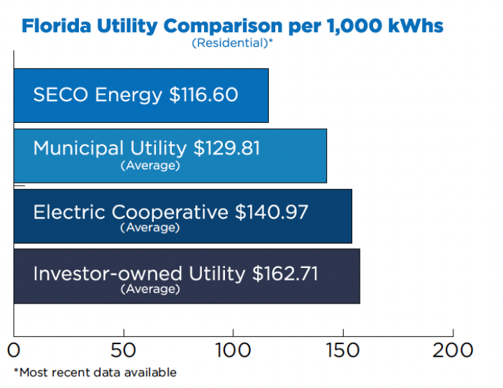
The Hot Bucks credit will reduce SECO Energy’s cost for residential service per 1,000 kilowatt hours (kWh) from $146.60 to $116.60 with bills generating as of October 1. The chart below compares SECO Energy’s residential cost for 1,000 kilowatt hours (kWh) with other Florida utilities.


This reduction places SECO Energy’s cost per kWh in a competitive position: lower than the average Florida Investor-owned, Municipal and Cooperative utility.


Our Mission, as a not-for-profit cooperative is to provide reliable and innovative energy services to our members and communities. Ensuring affordable energy service is a key component to fulfilling our role as your trusted source for energy solutions.


Best regards,


Curtis Wynn
Chief Executive Officer


SECO News September 2023 Atlantic Hurricane Season Update


We have reached the mid-point of the Atlantic hurricane season (June 1 – November 30). In early April, experts from Colorado State University’s (CSU) Tropical Weather and Climate Research forecast below-average hurricane and tropical storm activity this season.


The outlook has changed in mid-season. CSU is now predicting “above-average” levels of named and major storms with 18 projected this year. Nine of these storms will develop into hurricanes and four will be major hurricanes.


Not only are we faced with the possibility of higher-than-average tropical storm and hurricane activity this year, but CSU experts also predict the probability of a major hurricane making landfall in the United States is above the historical long-term average. As a reminder, a major hurricane is a Category 3-5 with sustained winds of at least 111 mph or greater.


STORM CONDITIONS AT ODDS?

While this forecast creates concern, there are uncertainties as to how two major weather conditions may influence the storm activity we ultimately experience in Florida. The warmer-than- normal Atlantic Ocean waters and a particularly strong El Niño weather pattern are conflicting signals. The El Niño climate pattern often breaks up storms in the Atlantic and tropics, but researchers are unsure if this pattern will continue with the extremely warm ocean waters.


Hurricanes and tropical storms form most often in September, which is why now is a good time to refresh your emergency hurricane supplies if you haven’t done so. At the time of this column printing, this year’s storms include Tropical Storms Arlene, Bret and Cindy formed in June, and Subtropical Storm Don formed in July.


Remain indoors and prepare to wait out the weather safely during a storm. Crews are dispatched to begin restoration only after wind speeds are less than 35 mph. If you shelter away from home, assess your home to make sure it is safe before you return. For homes with damage, turn off your main breaker if it is safe to do so. If appliances are wet, turn off each appliance’s breaker and then unplug. Contact a licensed electrician for repairs.


Most important, focus on your family’s safety. Stock up on hurricane essentials – buy early. When a storm approaches supplies sell out quickly.


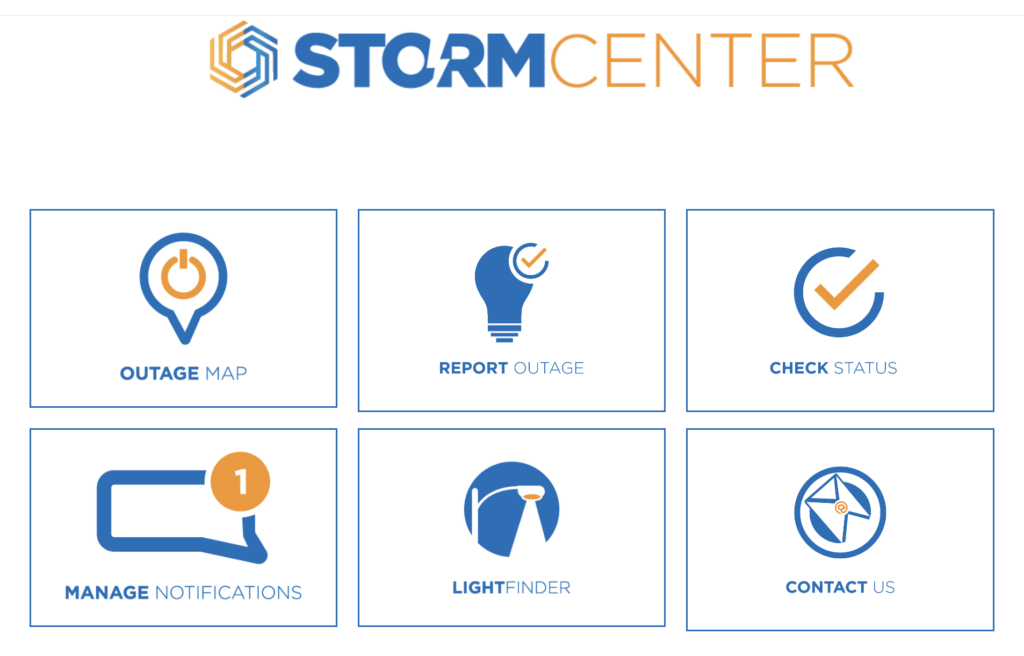
The SECO Energy Hurricane Handbook is your one-stop guide to being StormReady before, during and after a storm. Before a storm arrives, bookmark both our outage reporting and notifications platform StormCenter and our Daily Restoration Plan map on your smartphone or tablet. Find these tools at SECOEnergy.com.


SECO News September 2023 Emergency Operations A Message From Board of Trustees Secretary/Treasurer Morgan Hatfield

Visit your county’s EOC website and sign up for alerts from your local Emergency Operations Center (EOC) for resources such as shelter information, storm planning, evacuation orders and more.


To enroll in your county’s emergency alerts, visit www.FloridaDisaster.org. Enter the county or city and follow the enrollment link. Program your county’s number on your phone or bookmark the page in your smartphone for quick access.


MEDICALLY NECESSARY SERVICE AND SPECIAL NEEDS REGISTRY


Through the Florida Department of Health, persons with special needs can register with their local emergency management agency to receive assistance during a disaster. Visit www. FloridaDisaster.org to add your name or a loved one’s to the statewide registry.


Registering provides first responders with valuable information to prepare for disasters or other emergencies to meet citizens’ unique needs. Providing as much information as possible will allow emergency management officials to plan accordingly for future disasters. You will be emailed periodically to verify the information provided is correct and to make any necessary changes.


Unless you plan to seek shelter at an approved facility, back-up generation is critical if you are a member who relies on lifesaving medical equipment powered by electricity.


CITRUS COUNTY: SheriffCitrus.org > Emergency Management or (352) 249-2775

HERNANDO COUNTY: HernandoCounty.us > Departments > Emergency Management or (352) 754-4083

LAKE COUNTY: LakeCountyFL.gov > Services > Emergency Management or (352) 343-9420

SUMTER COUNTY: SumterCountyFL.gov > Government Services > Emergency Management or (352) 689-4400

LEVY COUNTY: LevyDisaster.com or (352) 486-5213

MARION COUNTY: MarionSo.com > Emergency Management or (352) 369-8100

PASCO COUNTY: PascoCountyFL.net > Live > Disaster Preparedness or (727) 847-8137


SECO Stands Storm Ready


Go to SECO Energy’s STORMCENTER to report an outage, check the status of an outage, see the estimated time of restoration, report an area light outage and manage your notifications.

SECO Energy StormCenter


Read the full September 2023 SECO News.

SECO Energy Recovers from Hurricane Idalia

SECO Energy is recovering from Hurricane Idalia as the storm’s outer rain bands and tropical storm-force winds moved across its Central Florida service area. SECO employees and contracted line and tree crews worked overnight Tuesday into Wednesday through inclement weather to restore service to members affected by power outages. SECO welcomed almost 500 mutual aid crews to aid in the restoration effort. 


In the last 24 hours, just over 10,400 members experienced a service interruption due to Hurricane Idalia. As of 12:00 p.m., just over 600 accounts remain out of service. The hurricane made landfall near Keaton Beach at 7:45 a.m., sparing Central Florida from the heaviest winds and most severe damage imposed by the hurricane. Idalia’s wind and rain bands extended into the SECO Energy service territory late Tuesday night and early Wednesday morning as it moved north, nearly 100 miles west of Tampa Bay. 


The Big Bend of Florida took the brunt of Hurricane Idalia’s Category 3 winds and unprecedented storm surge that pummeled the shoreline from Cedar Key to Horseshoe Beach. Extreme wind warnings were issued to parts of Taylor and Madison County, including the towns of Perry, Steinhatchee, Lee, Madison, Hanson and Pinetta. 


CEO Curtis Wynn was grateful for the limited impact Hurricane Idalia had on the not-for-profit electric cooperative’s 230,000+ members and praised the SECO team and mutual aid crews for their preparation. Wynn stated, “Our team was exceptionally well-prepared for Hurricane Idalia and their response was second to none. We caught a break – Hurricane Idalia could have turned east and left us with massive outages and destruction. There is no guarantee with the weather. StormReady means that we prepare for and are ready for emergencies that storms often create. We bring in the appropriate number of outside contractors and, with our own team of employees, apply the appropriate response plan.” 


StormCenter is SECO Energy’s outage and communications platform for members to report outages, check the status of an existing outage and enroll in outage communications and alerts via email, text, voice or all three. Visit StormCenter and bookmark it on your smartphone or tablet to report outages quickly and easily. 


SECO Energy’s Hurricane Handbook includes how to prepare before, during and after a storm. “Like” SECO Energy on Facebook and follow @SECOEnergy on X (formerly, Twitter) for news releases, and severe weather alerts affecting SECO Energy’s service territory. Manage your outage notification preferences at StormCenter. To see when SECO Energy crews and contractors are working in your area, visit the System Improvement map. To learn more about SECO Energy as a not-for-profit cooperative, visit SECOEnergy.com > Your Co-op > About.

SECO Energy Tracking Hurricane Idalia

SECO Energy continues to track the path of Hurricane Idalia as it moves through the Gulf of Mexico toward the Florida Peninsula. As expected, Idalia strengthened into a hurricane overnight and accelerated its movement north. At 11:00 a.m., the hurricane was positioned 240 miles southwest of Tampa, and its sustained winds were measured at 90 mph. Hurricane Idalia is moving due north at 15 mph and is expected to make landfall near Cedar Key early Wednesday morning. 


Probable path of Hurricane Idalia
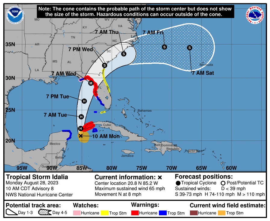
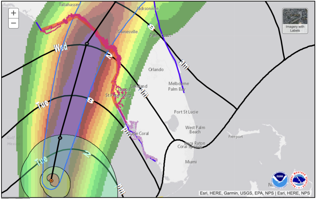
The onset of Hurricane Idalia’s winds is projected to be felt in the western SECO Energy service territories of Citrus, Levy, Marion and Sumter Counties this evening. Hurricane-force winds extend outward up to 15 miles from the center, and tropical storm-force winds extend up to 160 miles. These winds are expected to intensify rapidly overnight and result in a major hurricane by the time it makes landfall on Florida’s Gulf Coast Wednesday morning. 


Based on the National Hurricane Center (NHC) forecast, the risk of life-threatening storm surges and tropical storm-force winds along portions of Florida’s west coast is still a concern. The highest surge levels are predicted to fall within 10-15 feet above sea level. SECO Energy members should monitor updates to the forecast and follow advice given by local officials. 


SECO Energy members should prepare for outages due to Hurricane Idalia beginning overnight on Tuesday and into early Wednesday morning. If the current track stays in place, Marion County could experience winds between 60 – 70 mph and Citrus, Sumter and Lake Counties could have wind speeds between 40 – 60 mph. High wind speeds and possible flooding and tornadoes may create power outages that last for an extended period of time. 


CEO Curtis Wynn repeated his call for vigilance from members in advance of Idalia’s impact. Wynn stated, “SECO Energy is preparing for the effects of Hurricane Idalia. This coordinated, company-wide effort integrates assistance from other energy cooperatives and contractor partners ahead of the storm. Along with SECO Energy’s 80 line crew employees, we expect over 250 contracted line crews and 150 contracted tree service crews. After Hurricane Idalia has cleared our area, if needed, we will bring in additional support from our fellow electric cooperatives that were unaffected by the storm. The unfortunate consequences of power outages from tropical storms and hurricanes are a fact of life, but the duration of these outages is mitigated by the advanced preparations made by our leadership team, dedicated staff, and line technicians.” 


Wynn cautioned against complacency, adding, “I want to remind members not to take this storm lightly. High winds and heavy rain will increase the risk of downed power lines and trees. What was an ordinary activity a few days ago could be unsafe after a storm. Take time today to make any last-minute preparations, but if you don’t need to travel, stay home.”  


SECO’s priority is to restore service for shelters, hospitals, schools and government agencies (i.e., emergency ops centers, fire stations, law enforcement facilities). SECO Energy members who require electricity for life-sustaining medical equipment should consider relocating to a shelter.  


StormCenter is SECO Energy’s outage and communications platform for members to report outages, check the status of an existing outage and enroll in outage communications and alerts via email, text, voice or all three. Visit StormCenter today and bookmark on your smartphone or tablet to report outages quickly and easily.  


“Like” SECO Energy on Facebook and follow @SECOEnergy on X (formerly Twitter) for prize drawings, news releases, and severe weather alerts affecting SECO Energy’s service territory. Manage your outage notification preferences at StormCenter. To see when SECO Energy crews/contractors are working in your area, visit our new System Improvement map. To learn more about SECO Energy as a not-for-profit cooperative, visit SECOEnergy.com>Your Co-op>About.

SECO Energy Monitoring Tropical Storm Idalia

SECO Energy is preparing for the weather effects of Tropical Storm Idalia as it targets the Florida Peninsula. The storm is expected to strengthen into a major hurricane before it reaches the Gulf Coast of Florida.  


Based on the National Hurricane Center (NHC) forecast, the risk continues to increase for life threatening storm surge and dangerous hurricane force winds along portions of Florida’s west coast and the Florida Panhandle beginning as early as late Tuesday. Storm surge and hurricane watches are in effect for much of Florida’s west coast. SECO Energy members should monitor updates to the forecast and follow advice given by local officials. Florida Governor Ron DeSantis has declared a State of Emergency to 46 counties, up from 33 on Saturday. 


Tracking Tropical Storm Idalia

The current track of the storm shows that TS Idalia will most likely impact SECO Energy’s service area on Tuesday with rain and increased wind speeds. Outages on SECO’s electric system are possible overnight on Wednesday and into the early morning hours. If the current track stays in place, Marion County could experience winds between 60 – 70 mph and Citrus, Sumter and Lake Counties could have wind speeds between 40 – 60 mph.  

Tropical Storm Idalia 5-day cone


As of Monday morning, this storm was moving north over far western Cuba where later today it is expected to impose hurricane-force winds, heavy rainfall, the possibility of flash and urban flooding as well as landslides.   


CEO Curtis Wynn urges members to prepare for Tropical Storm Idalia. Wynn stated, “SECO Energy is watching Tropical Storm Idalia closely and preparing for the impacts this storm will have on our service area. While SECO is StormReady and prepared to respond to power outages, I urge members to prepare for major hurricane-force conditions. We expect this storm will impact SECO’s service area by late Tuesday, so now is the time to make safety preparations for your homes and families before its arrival. Still—be safe in efforts to prepare. Exercise caution and patience on the roads and continue to watch weather reports and follow the storm’s track.”  


StormCenter is SECO Energy’s outage and communications platform for members to report outages, check the status of an existing outage and enroll in outage communications and alerts via email, text, voice or all three. Visit StormCenter today and bookmark on your smartphone or tablet to report outages quickly and easily.  


Major weather events can cause extended power outages. SECO Energy reminds members to follow safety protocols when using a generator during a power outage. Generators emit deadly carbon monoxide (CO) that is odorless and colorless. Thousands of people die each year from CO poisoning. Never operate a generator in an enclosed space, including a garage. Always place the generator at least 15 to 20 feet away from your home and never near open windows.  


Before operating a generator, thoroughly read and review the owner’s manual. Never plug a generator directly into an electrical outlet. This current flow is deadly for utility personnel. Keep children away from an operating generator and store fuel in approved containers. Do not smoke while fueling a generator. Always operate a generator in a dry space. If it is raining, use a canopy or cover. SECO Energy’s Hurricane Handbook includes generator safety tips and how to prepare for before, during and after a storm.  


“Like” SECO Energy on Facebook and follow @SECOEnergy on Twitter for prize drawings, news releases, and severe weather alerts affecting SECO Energy’s service territory. Manage your outage notification preferences at StormCenter. To see when SECO Energy crews/contractors are working in your area, visit our new System Improvement map. To learn more about SECO Energy as a not-for-profit cooperative, visit SECOEnergy.com>Your Co-op>About.