StormCenter logo

Archive

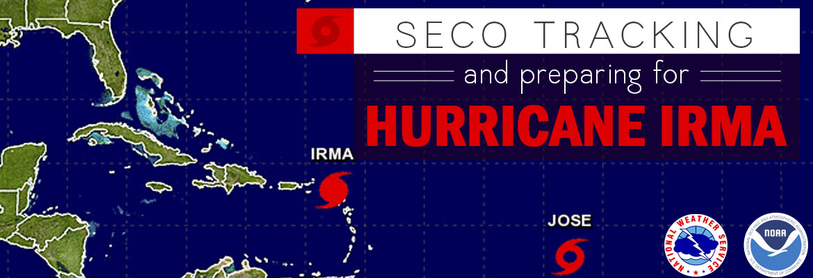
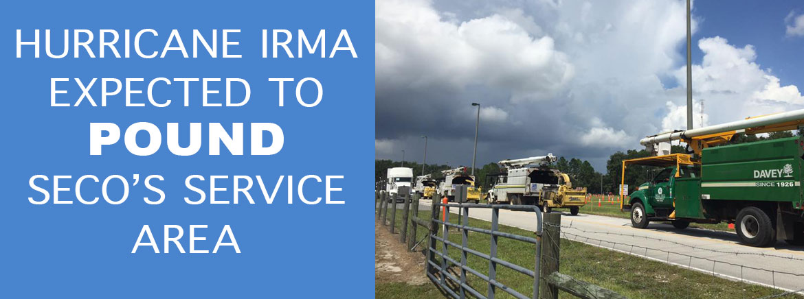
Hurricane Irma Expected to Pound SECO’s Service Area

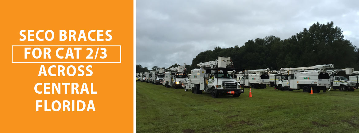
SECO Energy enacted its full emergency restoration plan late Friday afternoon in preparation for Hurricane Irma. The not-for-profit electric cooperative is preparing its members, employees and hundreds of line and tree trimming contractors for the hurricane to pound SECO’s service area.


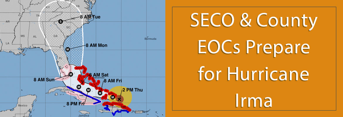
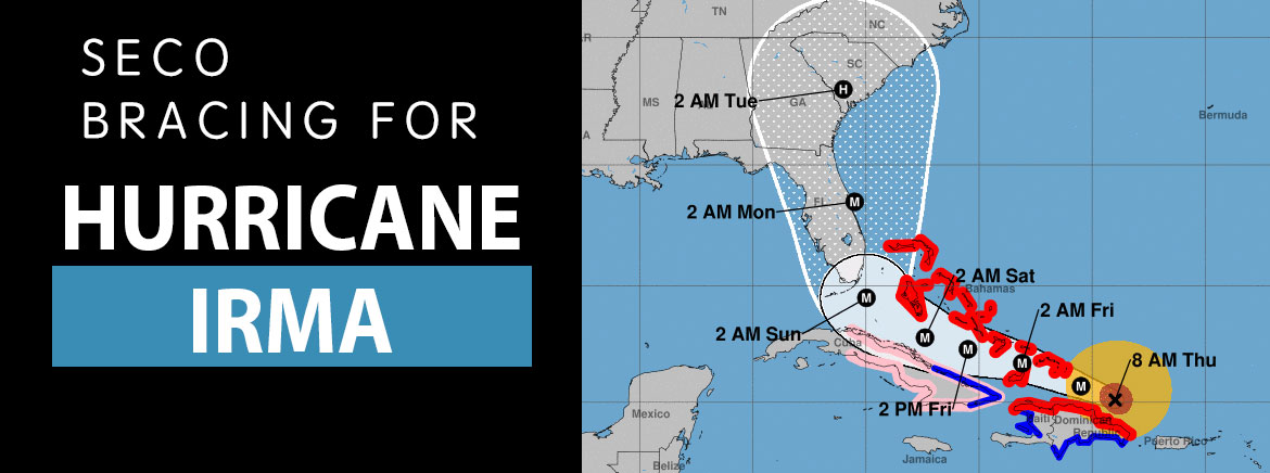
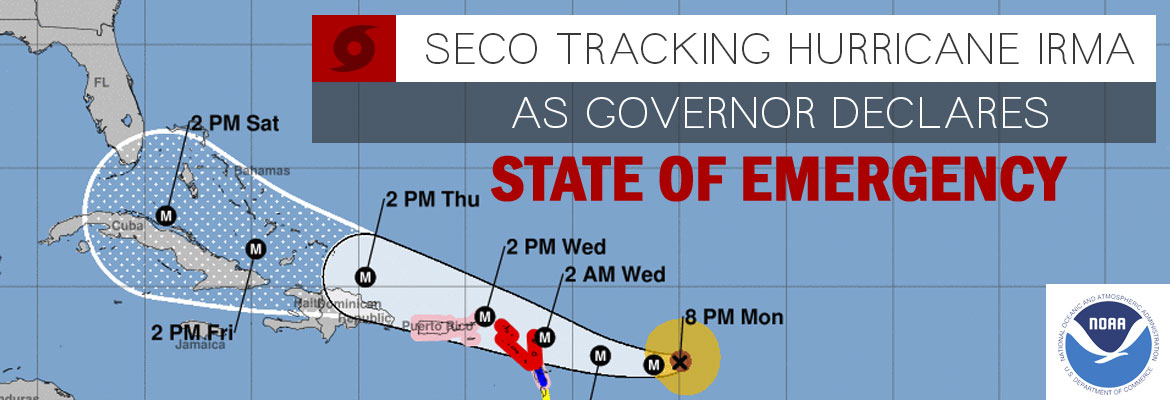
Currently, Hurricane Irma remains a Category 5 hurricane with maximum sustained wind speeds of 160 miles per hour. Irma’s center is located about 275 miles south-southeast of Miami, and it’s moving west at 12 miles per hour. Hurricane-force winds extend outward 70 miles from the center, with tropical-storm force winds extending 185 miles outward from the center.


Irma will turn northwest later today through Sunday morning, and is expected to make landfall first in the middle to upper Keys very early Sunday morning and then make another landfall near Naples Sunday afternoon. The track is shifting slightly to the west and when it makes landfall Hurricane Irma will be a Category 5 or high-end Category 4. Hurricane Irma will trek north-northwest Sunday afternoon and evening along or near Florida’s west coast picking up speed and gradually weakening before entering Central Florida.


Because Hurricane Irma strengthened back to a Category 5 early this morning, it will take time for it to weaken below hurricane strength. In addition, the slight westward shift in track means Irma will be over water for a longer period of time. For those reasons, we are now forecasting hurricane-force winds (up to 80 mph) over SECO service territory beginning late Sunday night and lasting through early Monday morning. Winds will likely decrease late Monday morning to below tropical-storm force early Monday afternoon. SECO’s area will be inundated with rain before, during and after Irma’s approach. There is also a chance of tornadoes within Irma’s feeder bands on Sunday. Hurricane Irma’s track will probably make slight shifts until it reaches Florida and makes landfall.


SECO employees and hundreds of line and tree contractors from across the nation will focus on power restoration throughout the duration of the event. Hundreds of bucket trucks, front loaders, cranes, and other heavy equipment is being assembled at SECO locations. When winds exceed 35 mph, restoration efforts are curtailed due to safety. It is possible with the hurricane timing and intensity that SECO won’t be able to conduct restoration activity beginning Saturday night until winds subside on Monday. SECO members should expect power to be off for an extended period of time due to hurricane-force winds.


SECO’s employees are Storm Ready and waiting to respond to outages spawned by Hurricane Irma. SECO is prepared for inclement weather and reminds members that it is best to be informed and prepared.


Have your emergency supplies including food, water, batteries, a radio, etc. in a safe place. If you are using a portable or backup generator during outages, never let the generator run in enclosed spaces. Generators emit carbon monoxide gas that is a silent, odorless killer. Ensure these are connected correctly. Visit SECO’s website for storm preparation tips and view an emergency checklist.


Floridians can access www.floridadisaster.org/shelters for shelter information by county, including general population shelters, pet-friendly shelters and special needs shelters. Please seek shelter if you or your loved ones need power to run life-saving medical devices.

Members with smartphones and tablets should bookmark SECO’s Storm Center for easy outage reporting and updates. SECO’s emergency restoration plan determines the system’s restoration priority of each affected feeder. Essential services such as hospitals, shelters, schools and government agencies are the highest priority. Line repairs that will restore power to large groups of members are next, and then individual electric services in less populated areas. To avoid scams and dangers, do not accept restoration assistance from someone who is asking for payment on the spot and is not a SECO employee or contractor. Under no circumstances would SECO ask for payment in the field during a restoration event. Do not attempt to reconnect services yourself.


As a not-for-profit electric cooperative, SECO is dedicated to being our members’ first source for accurate storm information. “Like” SECO’s Facebook page and “follow” the company on Twitter to stay updated about storms affecting our area.

SECO Braces for CAT 2/3 Across Central Florida

SECO Energy is enacting its emergency restoration plan in full alert this afternoon well before Hurricane Irma barrels through the state. SECO employees and hundreds of line and tree contractors from across the nation will focus on power restoration throughout the duration of the event. Hundreds of bucket trucks, front loaders, cranes, and other heavy equipment is being assembled at SECO locations.


The current National Hurricane Center (NHC) forecast indicates Hurricane Irma continues to move west-northwest at a speed of 16 miles per hour. Irma is currently a Category 4 storm. The projection cone has shifted, putting Irma’s path directly through the state’s center. Hurricane Irma is 250 miles wide, and by the time it reaches Central Florida, Irma could be a Category 2 or Category 3 hurricane which is unprecedented for Central Florida.


Tropical storm winds will likely affect SECO’s area before the storm makes landfall in south Florida on Sunday. Bucket trucks cannot operate in high wind conditions. When winds exceed 35 mph, restoration efforts are curtailed due to safety. It is possible with the hurricane timing and intensity that SECO won’t be able to conduct restoration activity beginning Saturday night until winds subside on Monday. SECO members should expect power to be off for an extended period of time due to hurricane-force winds.


SECO’s employees are Storm Ready and waiting to respond to outages spawned by Hurricane Irma. SECO is prepared for inclement weather and reminds members that it is best to be informed and prepared.


Have your emergency supplies including food, water, batteries, a radio, etc. in a safe place. If you are using a portable or backup generator during outages, never let the generator run in enclosed spaces. Generators emit carbon monoxide gas that is a silent, odorless killer. Ensure these are connected correctly. Visit SECO’s website for storm preparation tips and view an emergency checklist.


Floridians can access www.floridadisaster.org/shelters for shelter information by county, including general population shelters, pet-friendly shelters and special needs shelters.


Members with smartphones and tablets should bookmark SECO’s Storm Center for easy outage reporting and updates. SECO’s emergency restoration plan determines the system’s restoration priority of each affected feeder. Essential services such as hospitals, shelters, schools and government agencies are the highest priority. Line repairs that will restore power to large groups of members are next, and then individual electric services in less populated areas. To avoid scams and dangers, do not accept restoration assistance from someone who is asking for payment on the spot and is not a SECO employee or contractor. Under no circumstances would SECO ask for payment in the field during a restoration event. Do not attempt to reconnect services yourself.


As a not-for-profit electric cooperative, SECO is dedicated to being our members’ first source for accurate storm information. “Like” SECO’s Facebook page and “follow” the company on Twitter to stay updated about storms affecting our area.

SECO & County EOCs Prepare for Hurricane Irma

SECO Energy serves almost 200,000 members in Sumter, Lake, Marion, Citrus and in small parts of Levy, Hernando and Pasco Counties in Central Florida. Currently, no mandatory evacuations are in effect for the counties SECO serves, but Emergency Operations Centers (EOC) activated and are open to assist the public throughout Central Florida.


Sumter County: EOC Citizens’ Hotline is 352-689-4400. Shelters will be opening and schools are releasing early on Friday.


Lake County: EOC Citizens’ Hotline is 352-253-9999. Nine shelters are now open and schools are releasing early Friday and are closed Monday.


Marion County: EOC Citizens’ Hotline is 352-369-7500. Shelters are open only for Marion County residents – no host shelters available. Schools are closed on Friday and Monday.


Citrus County: No Citizens’ Hotline open. No school closures or shelters have been determined at the time of this release.


Floridians can access www.floridadisaster.org/shelters for shelter information by county, including general population shelters, pet-friendly shelters and special needs shelters.


As of Thursday afternoon, Hurricane Irma is maintaining its Category 5 intensity and wind speeds of 175 miles per hour. Irma continues its west-northwestward path at 16 miles per hour. The National Hurricane Center predicts Irma will make landfall in south Florida early Sunday morning.


SECO members will likely feel Irma’s effects late this weekend and early next week. SECO’s service area will likely experience tropical storm force winds, torrential rains and the possibility of tornadoes spawned by Hurricane Irma. Members should be prepared for the possibility of lengthy power outages.


Gather your emergency supplies and if you plan on running a portable or backup generator, now is the time to test that it is working properly and you have an adequate supply of fuel. Never use a portable generator in an enclosed area. Generators emit carbon monoxide gas that is a silent, odorless killer. Visit SECO’s website for storm preparation tips and to view an emergency checklist.


Members with smartphones and tablets should bookmark SECO’s Storm Center for easy outage reporting and updates. SECO’s emergency restoration plan determines the system’s restoration priority of each affected feeder. Essential services such as hospitals, shelters, schools and government agencies are the highest priority. Line repairs that will restore power to large groups of members are next, and then individual electric services in less populated areas. To avoid scams and dangers, do not accept restoration assistance from someone who is asking for payment on the spot and is not a SECO employee or contractor. Under no circumstances would SECO ask for payment in the field during a storm restoration event. Do not attempt to reconnect services yourself.


SECO’s employees are Storm Ready and waiting to respond if outages occur. As a not-for-profit electric cooperative, SECO is dedicated to being our members’ first source for accurate storm information. “Like” SECO’s Facebook page and “follow” the company on Twitter to stay updated about storms affecting our area.

SECO Bracing for Hurricane Irma

SECO Energy is keeping a close watch on Hurricane Irma as its track lands the giant Category 5 storm in Florida. The cooperative is enacting its emergency plan in full alert mode starting Friday at 4 pm through the duration of the restoration event.


Hurricane Irma continues to move on a west-northwestward track with an increased speed of 17 miles per hour, and maximum sustained winds of 180 miles per hour. The National Hurricane Center (NHC) has shifted the impact cone to the east overnight, but that shift isn’t enough to send Irma away from Florida. The NHC predicts Irma will make landfall along the southern east coast of Florida or the storm will travel up the east coast.


SECO members will likely feel Irma’s effects late this weekend and early next week. SECO’s service area will likely experience tropical storm force winds, torrential rains and the possibility of tornadoes spawned by Hurricane Irma. Members should be prepared for the possibility of lengthy power outages.


Gather your emergency supplies and if you plan on running a portable or backup generator, now is the time to test that it is working properly and you have an adequate supply of fuel on hand. Never use a portable generator in an enclosed area. Generators emit carbon monoxide gas that is a silent, odorless killer. Visit SECO’s website for storm preparation tips and view an emergency checklist.


Floridians can access www.floridadisaster.org/shelters for shelter information by county, including general population shelters, pet-friendly shelters and special needs shelters.


Members with smartphones and tablets should bookmark SECO’s Storm Center for easy outage reporting and updates. SECO’s emergency restoration plan determines the system’s restoration priority of each affected feeder. Essential services such as hospitals, shelters, schools and government agencies are the highest priority. Line repairs that will restore power to large groups of members are next, and then individual electric services in less populated areas.To avoid scams and dangers, do not accept restoration assistance from someone who is asking for payment on the spot and is not a SECO employee or contractor. Under no circumstances would SECO ask for payment in the field during a restoration event. Do not attempt to reconnect services yourself.


SECO’s employees are Storm Ready and waiting to respond if outages occur. SECO is prepared for inclement weather and reminds members that it is best to be informed and prepared. All SECO members should continue to seek out supplies for their emergency kits, and be ready to wait out the storm.


As a not-for-profit electric cooperative, SECO is dedicated to being our members’ first source for accurate storm information. “Like” SECO’s Facebook page and “follow” the company on Twitter to stay updated about storms affecting our area.

SECO Tracking and Preparing for Hurricane Irma

SECO Energy is tracking Hurricane Irma and continues to prepare for a track that will affect its service territory.


Currently, Hurricane Irma is a Category 5 storm with wind speeds over 180 miles per hour. The storm is located five miles north of Barbuda, and is moving west-northwestward at 15 miles per hour. Forecasters predict that Hurricane Irma will continue on this current path until at least Friday night, passing between Cuba and the southern Bahamas.


The National Hurricane Center (NHC) is predicting Hurricane Irma will make landfall in Dade County. The major models predicting Irma’s path shifted a bit easterly overnight, and predictions will continue to fluctuate over the next couple of days.


SECO’s service area will likely experience heavy winds, torrential rains and the possibility of tornadoes spawned by Hurricane Irma. Members should be prepared for the possibility of lengthy power outages.


SECO’s employees are Storm Ready and waiting to respond if outages occur. SECO is prepared for inclement weather and reminds members that it is best to be informed and prepared. All SECO members should continue to seek out supplies for their emergency kits, and be ready to wait out the storm.


If you have a portable or backup generator, now is the time to test that it is running properly and you have an adequate supply of fuel on hand. Members can visit SECO’s website for storm preparation tips and view an emergency checklist. For members with smartphones or tablets, bookmark SECO’s Storm Center for easy outage reporting and updates.


As a not-for-profit electric cooperative, SECO is dedicated to being our members’ first source for accurate storm information. “Like” SECO’s Facebook page and “follow” the company on Twitter to stay updated about storms affecting our area.

SECO Tracking Hurricane Irma as Governor Declares State of Emergency

SECO Energy is tracking Hurricane Irma and the impact the storm will bring to Central Florida. The peak of Atlantic hurricane season is here, and Irma is a strong storm that may target Florida later this week.


As of Tuesday morning, Hurricane Irma is a Category 5 hurricane and is located approximately 1,000 miles west-southwest of the Cabo Verde Islands. Thunderstorms associated with Irma are becoming more organized and conditions are conducive for Irma to continue develop and the intensity of the storm to increase. Hurricane Irma is moving west-northwest, and the storm is on track to affect south Florida as early as Saturday.


Governor Rick Scott has proactively declared a state of emergency for all Florida counties. The governor’s actions allow local governments ample time to gather resources well in advance of potential landfall. Currently, Irma is still too far away to determine its exact path, but SECO hopes the governor’s declaration spurs Floridians to prepare early and also allows comprehensive movement of utility crews, equipment and supplies within the state.


SECO employees are Storm Ready and waiting to respond if outages occur from Hurricane Irma. SECO is prepared for the possibility of inclement weather and would like to remind members that it is best to be informed and prepared. When storms threaten, supplies sell out quickly, now is the time to gather your emergency supplies and be ready to hunker down if Irma strikes Florida.


The National Weather Service recommends each household have enough food and water for each person in the house for one week. Stock your first aid kit, and include a 30-day supply of prescription medicines. Make sure your flashlights and weather radio are in good working order, with plenty of extra batteries. Fill your car with gas, and have cash on hand, gas pumps, ATMs and credit cards won’t work during power outages.


If you have a portable or backup generator, now is the time to test that it is running properly and you have an adequate supply of fuel on hand. Members can visit SECO’s website for storm preparation tips and view an emergency checklist. For members with smartphones or tablets, go online and bookmark SECO’s Storm Center for easy outage reporting and updates.


As a not-for-profit electric cooperative, SECO is dedicated to being our members’ first source for accurate storm information. “Like” SECO’s Facebook page and “follow” the company on Twitter to stay updated about storms affecting our area.

$3500 in Back-To-School Funds for Lake County Schools

As a not-for-profit electric cooperative, SECO Energy is committed to supporting education in the school districts in its service area. As part of SECO’s new back-to-school initiative, Lake County Schools is receiving $3,500 to enrich back-to-school activities in Lake County.


The funds are intended to support events like back-to-school teacher luncheons, new teacher welcomes and training sessions. The funds can also be used to support back-to-school events for students and parents such as after school back-pack programs and school supplies needs.


CEO Jim Duncan stated, “SECO serves almost 63,000 members in Lake County, and we know the school district will make good use of these funds for back-to-school programs. As a not-for-profit electric cooperative headquartered in Central Florida for almost 80 years, SECO believes that supporting education creates strong community partnerships. SECO’s school support initiative is a positive step for education in our area.”


Key Accounts Consultant Hank Bolduc presented the $3,500 check to the Lake County School Board during its board meeting on Monday. Chairman Marc Dodd stated “Education is woefully underfunded and we greatly appreciate SECO’s support.” School Board Superintendent Diane Kornegay graciously thanked SECO for its contribution to the District’s back-to-school events.


Education is a key cooperative principle, and SECO has long supported local students. For more than two decades, SECO has awarded scholarships to graduating high school seniors who live in a home served by SECO. During this 20-year program, upwards of $500,000 was awarded to over 250 local students to help them fulfill their dreams of a higher education.


Energy Services Specialists from SECO Energy often visit with local students to spread the word about electrical safety, solar power and saving energy. Presentations and speakers are available for groups and civic clubs of all ages. These presentations are like an educational field trip that comes to the schools and saves the time and expense of running buses. Request a speaker and presentation online or call 352-793-3801.


Learn more about SECO Energy’s commitment to community online. “Like” SECO’s Facebook page and “follow” @SECOEnergy on Twitter for news releases and cooperative updates.

Invest 92L Trekking East of SECO’s Service Area

SECO Energy continues to monitor developing tropical disturbances that could impact its service area.


Early this week, the National Hurricane Center (NHC) predicted the disturbance named Invest 92L could douse Central Florida with rain and occasional gusty winds. As of Wednesday afternoon, the odds of Invest 92L developing into more than a low-pressure trough are lessening. The system is predicted to move slowly northwest and north over Florida beginning Thursday before clearing the state this weekend.


SECO members should prepare for heavy rains, gusty winds and thunderstorms in the coming days while Invest 92L moves off into the Atlantic Ocean. There is a medium chance for the system to gain intensity and develop into a tropical depression or weak tropical storm, but the tropical storm force winds will remain offshore and not affect SECO’s service territory.


SECO’s employees are Storm Ready and waiting to respond if outages occur. SECO is prepared for inclement weather and reminds members that it is best to be informed and prepared.


If you have a portable or backup generator, now is the time to test that it is running properly and you have an adequate supply of fuel on hand. Members can visit SECO’s website for storm preparation tips and view an emergency checklist. For members with smartphones or tablets, bookmark SECO’s Storm Center for easy outage reporting and updates.


As a not-for-profit electric cooperative, SECO is dedicated to being our members’ first source for accurate storm information. “Like” SECO’s Facebook page and “follow” the company on Twitter to stay updated about storms affecting our area.

SECO Monitoring Ever-changing Tropical Forecast

SECO Energy continues to monitor this week’s ever-changing tropical forecast on Monday. With the peak of Atlantic Hurricane season fast-approaching, SECO encourages members to pay close attention to tropical weather alerts.


The National Hurricane Center (NHC) continues to track Invest 92L also known as Disturbance 2. Invest 92L is located a couple of hundred miles north-northeast of the southern Bahamas and continues to produce disorganized showers and thunderstorms extending toward Puerto Rico. Invest 92L is expected to continue moving west-northwestward at 15 to 20 miles per hour during the next few days.


Invest 92L’s current prediction cone encompasses all of Florida except for the panhandle. It is unlikely that Invest 92L will develop into a tropical storm or hurricane, but forecasters predict the system will bring rain and occasional gusty winds to SECO’s service area Thursday morning. Parts of SECO’s service area have been inundated with heavy amounts of rain and the ground is already wet. This saturation can lead to flooding and falling trees.


Forecasters are also watching Tropical Storm Harvey, which is breaking up near the Yucatan Peninsula and Disturbance 3, which has zero percent chance of cycle formation over the next five days.


SECO employees are Storm Ready and waiting to respond if outages occur. SECO is prepared for inclement weather and reminds members that it is best to be informed and prepared.


If you have a portable or backup generator, now is the time to test that it is running properly and you have an adequate supply of fuel on hand. Members can visit SECO’s storm preparation page for storm preparation tips and an emergency checklist. For members with smartphones or tablets, bookmark SECO’s Storm Center for easy outage reporting and updates.


As a not-for-profit electric cooperative, SECO is dedicated to being our members’ first source for accurate storm information. “Like” SECO’s Facebook page and “follow” the company on Twitter to stay updated about storms affecting our area.

SECO Watching Tropical Disturbances in Atlantic Basin

SECO Energy is keeping a close watch on the tropical disturbances forming in the Atlantic Basin as of Friday afternoon. The peak of Atlantic Hurricane season begins in September and seas are churning.


Invest 92 has the greatest possibility of impacting SECO’s service area, possibly early next week. This system is currently located 600 miles east-northeast of the Leeward Islands and is moving west-northwestward at 20 miles per hour. The National Hurricane Center (NHC) reports the upper-level winds are becoming less favorable for cyclone formation, but there is still a 60% chance that a cyclone will form within five days.


Another system forming is Disturbance 2. According to the NHC, Disturbance 2 is located in the far eastern Atlantic Ocean, moving west-northwestward at 20 miles per hour and chance of cyclone formation is only 40%. Forecasters do not believe Disturbance 2 will threaten Florida.


Tropical Storm Harvey is tracking west to Central America and Mexico at 21 miles per hour, and will make landfall on the Yucatan Peninsula early Monday morning.


SECO employees are Storm Ready and waiting to respond if outages occur. SECO is prepared for inclement weather and reminds members that it is best to be informed and prepared.


If you have a portable or backup generator, now is the time to test that it is running properly and you have an adequate supply of fuel on hand. Members can visit SECO’s website for storm preparation tips and view an emergency checklist online. For members with smartphones or tablets, bookmark SECO’s Storm Center for easy outage reporting and updates.


As a not-for-profit electric cooperative, SECO is dedicated to being our members’ first source for accurate storm information. “Like” SECO’s Facebook page and “follow” the company on Twitter to stay updated about storms affecting our area.