
Avoid Taking the Bait When Hackers Phish
Online phishing emails are a very real and dangerous trend. According to Wikipedia, the annual worldwide impact of phishing was as high as five billion dollars as of 2015. Today, this number is substantially more.
Being aware of what phishing emails look like and how to avoid them can save a company a lot of money, damage, and stress. Computer hackers love to go phishing, but instead of baiting hooks, they’re sending emails. They disguise what looks like a trustworthy email in order to obtain sensitive information from companies and individuals. Phishing is a form of social engineering designed to trick people into clicking what appears to be a valid link but instead causes damage in one way or another.
The reason hackers phish is to obtain sensitive and profitable information. By clicking on the link in their email, you may be doing anything from installing a virus to allowing the hackers into your computer network. Either of these is to gain information to be used against the company or for access to sensitive information such as a social security number or password. For example, the hacker may obtain a company’s username and password to their bank account and start making money transfers. They may gain trade secrets or future plans. This vital information is up for grabs if someone is not careful when receiving a phishing email.
Phishing emails are designed to blend in with emails employees receive every day. For example, if you work in the accounting world and are accustomed to emails with invoices, you might receive the same type of email from a hacker with only a couple of variations. One may think that a small change isn’t a big deal, but that little detail could make all the difference. Often, the emails give a time frame or sense of urgency in order to prompt a quick click without thinking. For example, claiming your bank account is hacked and you need to click the link to reset your password. Phishing emails also often contain grammatical errors. A good example of a phishing email will look something like this:
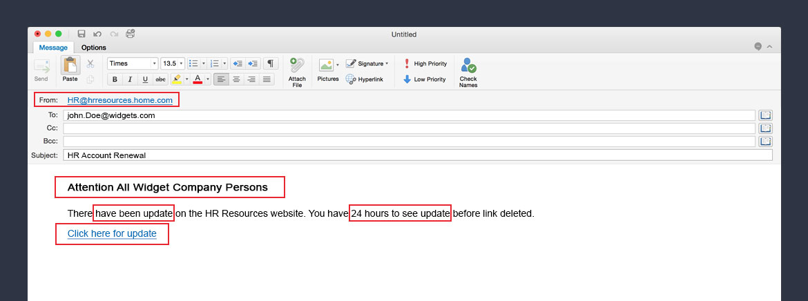
The easiest way to avoid falling victim to phishing emails is to always pay close attention. The “From” portion of the email address will often be similar to email addresses you would normally recognize. The slight difference could be as simple as an extra letter. Many times the sentences are not well written.
If an email is not one you’re expecting, question why it is being received. If the email is suspicious in any way, check with your company’s IT security team. If you receive an email asking to change a password for anything from a bank to a medical insurance site, call the company first or go directly to the website instead of clicking the link. Always check the legitimacy of the email before moving forward and warn others so everyone knows to be wary of a possible incoming attack.

One-size-fits-all Does Not Apply
When it comes to surge protection, there is not a one-size-fits-all solution. Sometimes consumers spend a lot of money on surge products only to be disappointed. Typically this doesn’t relate to the product itself, instead, it’s because the manufacturer’s recommendations for installation have not been followed, contributing to poor product performance.
When contemplating surge protection think about multiple layers of protection. The goal should be to make sure the protector is installed as close as possible to the source you’re trying to protect. Let-thru voltages increase for every foot of excess wire used in an installation. This means additional unwanted surge energy can travel directly to your equipment/systems increasing the potential for damage. The rule-of-thumb is to use as little wire as possible, avoid loops and bends, and follow instructions as outlined.
Although installation is a key factor in ensuring success, without a properly connected ground at the service entrance, dollars spent on surge protection are spent in vain. Have a professional test your grounding effectiveness before you get started. Once grounding is confirmed, draw a circle around your facility. Take a look at all lines coming in such as the electric, phone, satellite, and cable. Then determine the best way to protect each point of entry.
Besides primary surge protector at your service entrance or before the first breaker in your main panel box, add protection at all subpanels. Pay careful attention not to forget panels feeding security systems, outdoor lighting, gates, fountains, etc. Utilize point-of-use devices on indoor equipment such as computers, copiers, fax machines, and phone chargers. Statistics show up to 80 percent of power surges are generated internally. Although these are not the surges that do the most damage, they degrade equipment over time.
For more information on how to protect your commercial/industrial facility from damaging surges contact your SECO Energy Key Accounts Consultant. We’ll be glad to arrange for our surge vendor to help you formulate a plan to fit your company’s specific needs.

Member Spotlight: E. R. Jahna 474 Sand Mine, Clermont, Florida
E.R. Jahna Industries is American-owned and has been independently operated since 1934 from their headquarters in Lake Wales Florida. Building upon his construction and concrete background, Emil Jahna, Jr., started mining operations in 1946 supplying sand for local businesses producing concrete. Beginning in the late 1960s, E.R. Jahna’s Central Florida locations allowed them to flourish by supplying construction grade sands to Disney World, Interstate 4 and the surrounding building growth. Throughout the 1970s and 1980s, E.R. Jahna Industries purchased and started several new mines to expand their Florida footprint.
Today, E.R. Jahna remains owned and operated by the second and third generations of family. They continue to grow in the mining industry currently operating four sand mines in Florida and one in Savannah, GA. The company is a leading producer of high quality and reliable aggregate products – specifically sand. However, the term aggregate applies to a broad category of either fine or coarse particulate material such as silica sand, gravel, slag or crushed stone. These products are mined and used in concrete, concrete products, construction and every day modern life applications. Drain fields, road base, materials for concrete, sand for golf courses, roof tile, power poles, pavers, concrete pipe, concrete block and beach replenishment are all typical uses of aggregates here in Florida.
Although sand mining may sound simple, it is not! It requires a huge investment and an involved process to ensure a high quality product to meet end-use expectations. At E.R. Jahna’s in Clermont, Florida (served by SECO Energy), a dredge is used to remove sand from a pit. The sand is then transported through a pipeline to the sand plant. The sand plant washes and separates material through different processes to meet the customer’s end-use requirements. During its journey through the plant, the sand is screened of foreign debris, washed, sized, and the water removed creating the final sand aggregate product(s). Because the sand is so hard and abrasive on the metal processing equipment, continuous maintenance is required to meet production schedules and customer needs. E.R. Jahna’s maintenance program is key to its reliable production capabilities and quality products.
In order to compete in a competitive marketplace, E.R. Jahna continues to increase efficiency in extracting aggregates companywide. Many projects include sand plant re-configurations, efficient pump and motor upgrades, and an extensive geologic analysis of reserves and production yields. Over the next year, the E.R. Jahna 474 Independent Sand Mine will see drastic capital improvements including the total rebuild of the sand plant. With new technology and continued learning, E.R. Jahna can remain competitive and on the forefront of the aggregate mining industry.

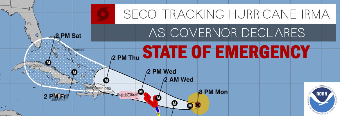
SECO Energy Is “Storm Ready,” Are You?
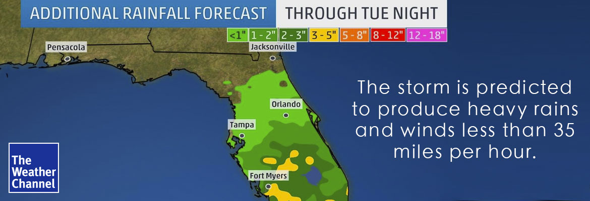
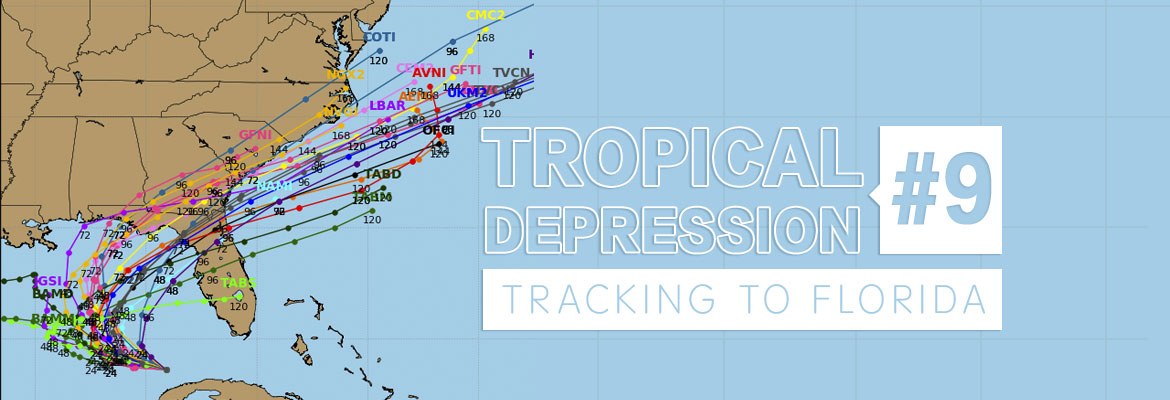
Hurricane season began on June 1st and SECO Energy stands “Storm Ready.” Our System Operations Center is staffed 24 hours a day, 7 days a week and crews and support staff are available around the clock. Our Emergency Restoration Plan serves as a guide to ensure the timeliest restoration of service even under the most adverse circumstances. SECO Energy’s operating plan is continually evaluated and updated annually because we understand the importance of electricity to your business. However, this is only half the battle. You too must be storm ready.
For your business, being storm ready may not necessarily apply to a weather event or service interruption at your location. Depending on your operation, there could be a number of things with the potential to impact your bottom line. Having a plan in place to deal with concerns increases the chances of your business surviving. Statistics show that ninety percent of companies fail within a year unless they can resume operations within five days after a catastrophe.
In today’s world, businesses must prepare for the impacts of many hazards including natural disasters like hurricanes, tornados and flooding. Then there are human caused hazards, acts of violence and terrorism, technology-related issues and equipment failures. Whether the disaster is major or minor, anything that has the potential to cease operations at your location for a prolonged period of time can be crippling. A good plan is necessary to prevent this.
Many experts advise developing a preparedness plan consisting of the five steps as follows:
- STEP ONE-Program Management
Assign an administrator to organize, develop and identify the regulations that establish the minimum requirements of your program.
- STEP TWO-Planning
Gather information and examine ways to identify, assess, prevent and reduce hazards and risks. Done correctly, this would include a business impact analysis.
- STEP THREE-Implementation
Create a written plan to address resource management, emergency response, communication, operational continuity, IT, employee assistance, incident management and training.
- STEP FOUR-Testing and Exercises
Evaluate your plan on an ongoing basis by conducting multiple types of training and exercises, using the results to evaluate the effectiveness of the plan.
- STEP FIVE-Program Improvement
Establish a cycle of review and methods of evaluation and make the necessary changes to keep the plan current.
Related to your hurricane preparedness plan, be sure your plan includes actions to be taken before, during and after the storm. Keep the lines of communication open for everyone involved. It is imperative employees understand their assignments and reporting procedures. Be sure site issues, such as boarding up buildings, securing or relocating signs or equipment and removing loose debris, are done before the storm’s arrival. After the storm, wait until the area is declared safe before proceeding to survey damage. Then, survey the site for safety hazards, downed power lines, leaking gas or fluids and damage to foundations or piping. If you lose power, report the outage to your SECO Energy representative and visit our Storm Center and Facebook at SECOenergy.com for progress updates and to monitor restoration efforts.
Remember, you are not alone. There are many resources to assist you in preparing for disasters. FEMA, the State of Florida and the Small Business Administration all have resources available on-line including free sample emergency plans, preparedness checklists and templates.

Energy Conservation Tips for Small Retailers
Saving energy makes good business sense. Not only is conserving energy good for the environment, but it’s also good for your bank account. Implementing a few simple energy conservation strategies can help reduce your monthly energy bill.
Historical Usage
By monitoring your energy usage on your monthly electric bill you can identify patterns and understand normal monthly consumption. Knowing how and where energy is consumed is a first step to reduce costs and lower consumption.
Energy Efficient Equipment
Whenever possible, upgrade or retrofit light fixtures to CFLs or LEDs and consider adding occupancy sensors to turn lighting off in storerooms or other seldom-used areas. Make it convenient to unplug all equipment, not in use, with the aid of a power strip.
Control Your Thermostat
Many offices seem to have ongoing thermostat wars that can actually decrease your energy efficiency and lead to higher energy bills. Prevent this by investing in a programmable thermostat. According to ENERGY STAR® you can save $180 annually. Additional savings can be achieved if you program a more conservative setting during unoccupied hours.
Keep the Heat Outside
Ensuring your business is properly insulated and taking steps to reduce drafts can help lower your monthly bill. Door seals, window coverings, and door closers are just a few examples of low-cost ways to conserve energy.
For more information on how to save, contact your SECO Energy representative and arrange for a free personalized energy assessment of your facility.


